There is so much more to Joshua Tree National Park than just a quick peek at those iconic trees. This beautiful area three hours west of LA is home to some fantastic hikes that showcase some of the best of the Mojave Desert: epic views, ever changing landscapes and a feeling that you are entering another world. Whether you want a short stroll, a more strenuous hike or to simply hop out the car and look at the views, we’ve put together the 6 best Joshua Tree hikes for you.
The Best Joshua Tree Hikes
Best Joshua Tree hikes
The great thing about Joshua Tree is that there are plenty of short easy hikes for people who want to see this incredible mountain, but don’t want to take on a really lengthy, steep hike.
There are also plenty of trails for people who fancy a bit more of a challenge as well.
Joshua Tree hikes map
There are two sections of Joshua Tree where the majority of trails are situated: Black Rock Canyon and Park Boulevard. In our opinion, the hikes around Black Rock Canyon in the west of the park are the best, with wilder trails that feel like you’re going further into the wilderness.
They are also much quieter too, we only saw a handful of people in this area. The hikes on Park Boulevard are still great and have plenty of beautiful views, but are a lot shorter and busier - although still by no means heaving when we visited in winter.
We would recommend spending time in both areas if you can.
Distance is something you should factor in when planning your hikes as the park is pretty big! It ranges from Hidden Valley & Barker Dam (30 minutes from Joshua Tree) to Cholla Garden at nearly an hour away.
Our favourite hike: Panorama Loop, Black Rock Canyon
Distance: 10.8 km (6.7 miles)
Type of walk: Loop
Difficulty: Moderate
Elevation: 364 metres
Time we took: 2 hours 35 mins
The Panorama Loop from Black Rock Canyon is - in our opinion - the best hike in Joshua Tree. If you want a walk that takes you far into the park and offers some beautiful views without the crowds this one is for you.
It also has a huge concentration of Joshua Trees and plenty of cactus and other plants to make for a beautiful desert landscape. It’s also the longest walk in the park which doesn’t require a car shuffle (the longest, Boy Scout Trail, is 8 miles one way and a car shuffle is highly recommended).
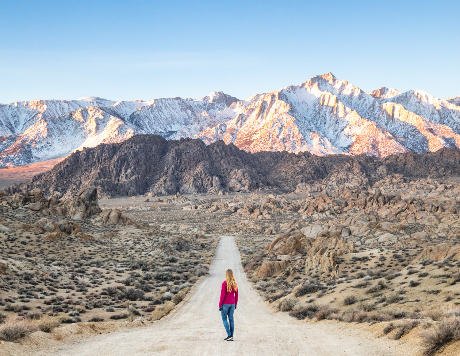
The best Joshua Tree Hikes: The view back to the Sierra Mountains
The track starts just outside the visitor’s centre at the Black Rock Canyon campground, and is gradually uphill from the start. It’s well signposted at almost every turn except for the very beginning as you walk through the campground (it’s left at the water tank). The trail takes you into the desert and towards the hills, passing many Joshua Trees and scrub along the way.
After around 2.7km (1.7 miles) you’ll come to the sign saying you have reached the panorama loop. We were advised to hike clockwise by the visitors centre for better views.
The path soon enters a small canyon where the desert seems to come alive with cacti and other plants bursting into life around you (clearly when it rains the water funnels through). Soon the track heads steeply uphill and you’ll get some beautiful views of the mountains if you look behind you as you climb. For us the mountains were snow capped which was absolutely beautiful.
The path then zig zags up to the highest point and it is views all the way. Note that this is quite exposed to the elements, we hiked on a very windy day and it was ferocious but the trail is not too narrow and it never felt unsafe.
From the trail’s high point it is basically flat and downhill all the way, the hard work is done and you can simply relax and enjoy panoramic mountain views before walking through another huge Joshua Tree grove.
The final section is retracing your steps back to the campground along the same route that you started on.
Top tip: We’d originally been planning to hike Warren Peak but a tip from the lovely lady at the visitor’s centre recommended this one and we weren’t disappointed. If you are thinking of hiking both Warren Peak and the Panorama Loop we’d advise doing it on the same day if you have the energy as they share the 5.4km (3.4 miles) of the same track.
Read next: 16 Big mistakes to avoid in Yosemite National Park
Getting to the Panorama Loop
Black Rock Canyon Campground (where the hike starts from) is 9 miles away from Joshua Tree town and should only take 15 minutes by car. It is apart from the rest of the park and is at least 21 miles (30 mins) away from any other walk.
The best short walk - Split Rock
Distance: 3.2 km (2 miles)
Type of walk: Loop
Difficulty: Easy
Elevation: 75 metres
Time we took: 45 minutes
Split Rock was our favourite short walk in Joshua Tree with plenty of varied terrain to take in and many strange looking rocks. The walk can be combined with Skull Rock, but we wouldn’t really recommend it (more on that later).
The trail has a few small ups and downs, but nothing to worry about. The walk starts by taking you into a small valley and you quickly feel like you’re a long way away from any road or car in the park (something that you don’t always feel in Joshua Tree). The most fun part in our opinion is the beginning section where you are walking over lots of the huge rocks the area is famous for (not in the least slippery).
You’ll pass through beautiful desert landscape and the trail is another very quiet one, we’re not sure why as it is fantastic and so close to the famous Skull Rock. Look out for Bighorn Sheep along the way.
The best hikes in Joshua Tree: Cartoonish face on the Split Rock trail
If you like looking for shapes in the rock formations a highlight will be a few strange looking rocks which look just like faces, including one with a set of nostrils. It takes a little imagination, but you can see it!
Getting to Split Rock
Split Rock is at the far eastern part of Joshua Tree National Park and is about 27 miles from Joshua Tree town. Split Rock is very close to Skull Rock (5 minutes) and Ryan Mountain (10 minutes).

A good short hike - Barker Dam
Distance: 2.2 km (1.4 miles)
Type of walk: Loop
Difficulty: Easy
Elevation: 24 metres
Time we took: 40 minutes
Barker Dam is one of the most popular walks in Joshua Tree and is a great introduction to the desert. If you have just one day in Joshua Tree and are only really looking for one short hike, make it this one. At only 2.2km long with virtually no elevation, this is a hike that anyone can do (although it does cross uneven terrain).
The walk, which was created by cowboys to water their cattle, is characterised by two things: epic boulders and a lake created by a dam - something you wouldn’t expect in the middle of an incredibly dry desert. It is a beautiful part of the park, which reminded us a little of Alice Springs in Outback Australia.
The best Joshua Tree Hikes: Classic Joshua Tree landscape
There are plenty of places to see the iconic Joshua Tree composition - Joshua Tree + boulders + desert. We found a particularly good area after the dam where you could see several beautiful trees with a photogenic backdrop.
It is also a good place to see Petroglyphs created by native Americans to show water sources and other vital information. They are about 30 seconds off the main trail and signposted. Sadly we’ve read that there has been some vandalism which have altered some of the petroglyphs from their original form.
Getting to Barker Dam
Barker Dam is very easy to get to and is one of the closest walks to the park entrance. Parking for the trail is 15 miles from Joshua Tree town and should take about 30 minutes.
Barker Dam is also very close to Hidden Valley (5 minutes away), Ryan Mountain (10 minutes) and Keys View (15 minutes).

Read next: Death Valley walks that you shouldn’t miss
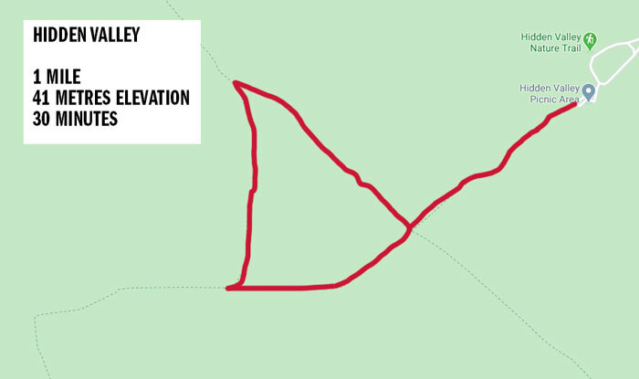
Another great short hike - Hidden Valley
Distance: 1.69km (1 mile)
Type of walk: Loop
Difficulty: Easy
Elevation: 41 metres
Time we took: 30 mins
Hidden Valley is another great hike that’s pretty short and easy (although again with some steps and uneven terrain). The walk takes you into - surprise, surprise - a hidden valley which is only reached by a narrow pathway in.
The track isn’t quite as diverse as the others mentioned above, but you do get to see some beautiful boulder sections, hills and more fantastic desert landscape. For only 1.7km it is worth spending the half an hour needed to do this short walk!
It is quite easy to lose the track, so keep a keen eye out for those brown signs and any hint of where the path goes (this can often be rocks or branches put down to discourage a certain direction).

The best Joshua Tree hikes: The middle of the Hidden Valley Trail
Whilst we loved this trail if you only have very limited time in the park you probably don’t need to do both Hidden Valley and Barker Dam. If we had to choose one we’d go for Barker Dam.
Getting to Hidden Valley
Like Barker Dam, Hidden Valley is the closest to the edge of the National Park. It is 14 miles away from Joshua Tree town and should take about 25 minutes to get to.
We recommend combining this walk with the Barker Dam trail if you plan on doing both as they are pretty close together and neither take very long to complete.
Read next: Why we love visiting Zion in the Winter
A quick work out - Ryan Mountain
Distance: 5.2 km (3.2 miles)
Type of walk: Return (out and back)
Difficulty: Moderate
Elevation: 256 metres
Time we took: 1 hour 30
Weather may have had an impact on our opinion of Ryan Mountain as it was incredibly windy and freezing cold when we did this hike. Maybe with some better weather it would have been higher in our opinion but overall we rate it below all the others mentioned above.
The hike is uphill immediately and is pretty steep at first. From here the trail circles around a nearby hill and continues gradually up to the top of Ryan Mountain. Along the way you’ll get some good views of Joshua Tree National Park in a few different directions, showing the diversity of this landscape.
The trail is very well maintained and though it is rocky in places footing is not difficult. We thought it would be slippery coming back down the trail but it was actually fine.
The best Joshua Tree hikes: The start / end of the trail
Ryan Mountain is a good hike to do if you fancy a bit of a work out and having some elevated views in the main part of the park. However, we think you’re better off going to the Panorama Loop at Black Canyon Rock if you can only pick one!
Getting to Ryan Mountain
Ryan Mountain is in the main part of Joshua Tree National Park, taking just over 30 minutes from Joshua Tree town. Ryan Mountain is also conveniently close to Keys View, Barker Dam, Hidden Valley, Split Rock and Skull Rock, so you can easily combine all of these together with an early start.

Read next: Zion National Park Walks ranked
Best Joshua Tree sunrise spot - Cholla Cactus Garden
Distance: 0.2 miles
Type of walk: Loop
Difficulty: Very easy
Elevation: 0
Cholla Cactus Garden isn’t really a hike at 0.2 miles in length, but it is a beautiful spot for sunrise. Cholla has hundreds of cacti, closely packed together which glow in the morning light - something we didn’t expect! It is a beautiful sight and well worth making the early start for.
The best Joshua Tree hikes: The beautiful Cholla Cactus Garden
The cactus garden looks out the vast desert and surrounding mountains which turn a beautiful golden colour on a clear morning. After the sun rises, the mountains turn pale red for a few minutes before settling to a golden tinge. We didn’t expect it to be such an impressive scene, but sunrise at Cholla Cactus Garden was easily a highlight of our trip to Joshua Tree.
Getting to Cholla Cactus Garden
Cholla Cactus Garden is the longest journey in the park and is 35 miles from Joshua Tree town (taking about 45 minutes). The nearest other hike to it is Skull Rock which is 12 miles away.
Read next: What to expect from Waterhole Canyon
Best view for sunset - Keys View
If the weather is good, then Keys View is one of the best views in the park. Looking out to the Coachella Valley, the view looks over rugged mountains and out for miles.
Sadly it was like a jet engine was placed in front of us as the winds were ferocious both times we visited. In different conditions it is the kind of place you could sit for hours looking out over the spectacular mountain ranges.
The best Joshua Tree hikes: A semi-sunset at Keys View
Getting to Keys View
Keys View is about 21 miles from Joshua Tree Town and takes about 40 minutes to get to. The viewpoint is along a road that turns off Park Boulevard and is a further 15 minutes from hikes such as Hidden Valley, Barker Dam or Ryan Mountain.
So we know this a blog about the best hikes in Joshua Tree but we had to mention that one of the park’s most famous trails is a real let down…..
The dud - Skull Rock
Distance: 2.6 km (1.6 miles)
Type of walk: Loop
Difficulty: Very easy
Elevation: 91 metres
Time we took: 35 minutes
Despite being one of the most popular sights in Joshua Tree, the Skull Rock Trail was a disappointment. The majority of the track is actually along the road and there was nothing really to make this trail remarkable other than the fact it starts at the rock that is shaped like a skull.
If you are keen to see Skull Rock hop out and take a photo and then hike elsewhere.
The first half mile or so is through boulder territory but not as pretty as Hidden Valley or Barker Dam and the rest is main road. The road is attractive enough but it’s the same road you’ll have been driving around so entirely unnecessary to hike it too!
We’d put this at the bottom of the list of hikes to do.
Getting to Skull Rock
Skull Rock is 23 miles away from Joshua Tree town and should take about 40 minutes to get to. It is also close to Split Rock (5 minutes) and Ryan Mountain (10 minutes).
Read next: The best hikes in the Grand Canyon
Essential Information
Where is Joshua Tree National Park?
Joshua Tree National Park is about three hours west of Los Angeles in Southern California. The park has four entry points: Joshua Tree (the town), Black Rock Canyon, Twentynine Palms or a long way outside of Indio along route 10. If you want to do the main hikes then Joshua Tree town is the place to start as the majority of the hikes can be reached on Park Boulevard
Joshua Tree Entry Cost
If you are planning to visit three or more parks in a year we recommend buying the annual National Parks Pass - America the Beautiful. This costs $80 and gives unlimited access to any national park in the USA.
Otherwise, here are the non-annual pass prices:
Entrance Fee by car (valid for 7 days): $30
Motorbike: $25
By bike or on foot: $15
Seeing as the entrance is a long way away from town, unless you are really fit you won’t want to be on a bicycle or on foot!
Joshua Tree Opening Times
Joshua Tree is open 24 hours a day, but the rangers request that you leave the trails by sunset.
Best time to visit Joshua Tree National Park
Spring and Fall are the best times to hike in the park when the weather is generally good. Summer can be incredibly hot, meaning to do anything more than the shortest trails will require an early start to avoid the worst of the heat. Winter can be great but it can also be incredibly cold as we can attest too. We had frost and and crazy wind giving a ‘feels like’ temperature of -4C.
Packing suggestions for Joshua Tree
Having the right gear can make a huge difference, whether it’s hiking during the hot summers, or the potential freezing cold temperatures in the winter. Here’s what we pack and have relied upon for years:
Day Pack: Osprey Talon 22 (we’ve owned this for years). Check on Amazon, REI or direct with Osprey
Hiking Boots: Merrell Moab (for men and women). We’ve both used these for over three years and they just keep going. Check them out on REI or Amazon
Trekking poles: We’ve used Black Diamond for years as they are light, solid and durable. Check out REI or Amazon.
Reusable water bottle: To avoid single-use plastic. Check then out on REI or Amazon
Audiobook or Podcast: If you’re on your own (or you’re on a longer trail) an audiobook or podcast can really help. Amazon are offering a free trial for Audible, which has thousands of the latest audiobooks to get stuck into. Click here to find out more.
For winter
Where to stay in Joshua Tree
Casa De Frank
We’d highly recommend staying in Joshua Tree town for easy access and to make full use of your one day in the park, although you could also visit using Palm Springs as a base too (roughly 35 miles away).
If you’re looking for a great option, then check out Casa De Frank which has really high ratings (we picked the trailer in the end because the only remaining room at the Casa was with shared facilities).
Check the latest prices & reviews on:
This post may contain affiliate links, meaning at no additional cost to you, that we will earn a small commission if you click through and decide to make a purchase. This helps towards the costs of running our website. Thanks for your support.
Like it? Pin it!

Follow us on Social Media
Are you planning a trip to Joshua Tree? Is there somewhere you think we should go hiking in California? Let us know in the comments below!