

The Stanley Glacier hike is the most popular walk in Kootenay National Park for good reason. This short and relatively easy hike (by Rockies standards) gets you up close to a glacier and huge waterfall with heaps of amazing views along the way. It’s close enough to Banff to easily fit into a morning or afternoon but just far enough away that you lose the crowds.
As well as the stunning alpine views, you’ll see something quite different - a large area of forest growing back after the 2003 wildfire. Burnt remnants sit alongside new growth.
Here’s all you need to know about the Stanley Glacier hike and why it should definitely be on your must do list.
The Stanley Glacier Trail
Trail stats
Distance: 9km (return)
Elevation: 380m
Difficulty: Easy to moderate
Time taken: 2 hours 20 total
Start point: Stanley Glacier Car Park
The reality of the trail
The Stanley Glacier trail is actually a lot easier than the signs say (a rarity in the Rockies!). We’d read it was 11km long and nearly 500 metres of elevation!
It was shorter and shallower than the signs say, so don’t let it put you off! The readings above are from our Apple Watch which is usually fairly accurate.
The start of the trail
The trail starts by crossing a river and then heads gently uphill on a series of switchbacks. You might think that sounds like a typical Rockies steep hike, but it’s actually one of the shallowest gradients we’ve done in this area, making it much easier than most.
The path is in good condition which makes for quick walking and it’s quite gratifying to see the road become smaller and smaller in the distance.

The views of the Kootenay Valley are beautiful too, and the well graded track means you can take them in instead of looking at your feet.
This is the section that was hit badly by wildfire. What makes it so fascinating is that you can see how fast the forest is trying to grow back.
There were still charred tree trunks, but new conifers were already at Cat’s head height, which is pretty rapid!

This new growth was interesting to take in and it won’t be long before it becomes a dense forest once again.
After you’ve made your way up the switchbacks the path flattens for a kilometre, a flat stretch in the Rockies? Bliss!
The trail crosses a river and heads towards the mountain tops before reaching a steep rocky hill. This is where you need to start paying attention to your footing and whilst it isn’t difficult it does require stepping over uneven rocks.

You’ll have seen the largest waterfall already in the distance, but the trail will take you a lot closer. This section of track is a lot steeper than the earlier section but it doesn’t last long.
It’s not long before the path seems to disappear and there looks to be two different routes. We took the steeper track and soon reached the boulder field.
This is when we saw the end of maintained trail sign which a few people missed when they followed the lower track - not that it really matters because it is pretty obvious the trail ends in this area anyway!
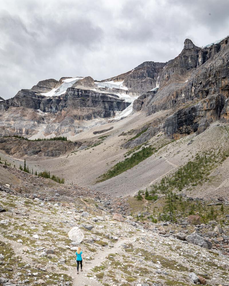
It’s actually only 4.2km to this sign and most people chose to stop here. It’s a huge expansive area with loads of rocks to sit on and take in the views of both Stanley Glacier and the waterfall.
You can also opt to cross the boulder field which is not too difficult and carry on up a scree slope for closer views of the glacier. The trail is really obvious and not difficult in good weather.
Cat gave it a go, but the rain started more heavily and the wind picked up so she didn’t get all the way to the end.
You get closer views of the glacier, waterfall and a cave but if you don’t head up you haven’t missed out because the views from the end of trail area are magnificent.

You can just about see Cat making her way up the scree slope!
The upper scree slope area is also where black bears have been frequently sighted so keep an eye out.
Read next: 10 stunning Revelstoke Hikes you need to do - British Columbia and The best things you must do in Lake Louise
The way back
The hike back is really easy. Once you’ve gone down the rocky hill, it is a smooth and downhill hike all the way and the excellent trail conditions make for a speedy descent.
There aren’t many places in the world where a couple of hours easy hiking will get you to such amazing views.
The Stanley Glacier hike is a must for anyone who wants to get to some fantastic views without the huge climbs the Rockies are famous for.

Fossils
We’d seen at the start of the trail there was a sign saying that you can find fossils in places along this trail. We didn’t go out of our way to find them, but we did meet a family who were keenly trying to search for some (with no luck). This could be a way of making the hike more enjoyable for kids by motivating them to hunt for the fossils but if you’re really keen you might want to join one of the Parks Canada led guided tours.
Read next: The stunning Larch Valley hike in Lake Louise and The Parker Ridge Trail - the best hike on the Icefields Parkway
Essential info about the Stanley Glacier hike
Bear safety on the Stanley Glacier hike
Black bears had been regularly spotted on the upper trail slopes when we hiked the trail, though we didn’t spot any ourselves.
Everyone who had spotted the bears had said they were completely disinterested in humans but it’s always good to be aware and carry bear spray in the very unlikely event one goes rogue.
Best time to hike the Stanley Glacier trail
The Stanley Glacier hike is most easily completed between June and September when the trail should be relatively snow free (we hiked in August when there was no snow whatsoever).
Hiking outside this season and if there is snow will make the trail considerably more difficult and could pose an avalanche risk. Checks with the Parks Canada website for up to date trail conditions.
As this is a short trail (and few people hike it) you won’t have to worry about the time of day to visit to avoid the crowds.
Entrance fee for Stanley Glacier Hike
Stanley Glacier falls under Kootenay National Park and requires purchasing a permit before you visit. You can buy it on Highway 1, but the queues here can be awful.
You can buy it online by clicking here to go to the Banff & Lake Louise Tourism website. It costs $9.80 CAD per person per day ($7 USD).
If you plan on visiting multiple National Parks in Canada, you could look at the annual pass. It costs $136.40 CAD ($102 USD) for a whole car and will get you entry to 80 parks in Canada.
Getting to the Stanley Glacier hike
The Stanley Glacier hike is in Kootenay National Park which isn’t far from Banff. It should be a 30 minute drive to reach the trailhead which has its own parking lot.
This post may contain affiliate links, meaning at no additional cost to you, that we will earn a small commission if you click through and decide to make a purchase.
This helps towards the costs of running our website. :-)
Like it? Pin it!

Follow us on social media
Are you planning a trip to Banff? Would you have a go at the Stanley Glacier hike? Let us know in the comments below!


