

The fourth of our 9 Great Walks of New Zealand was the Rakiura Track on Stewart Island. For those who aren't familiar with New Zealand, Stewart Island lies one hour by ferry from the South Island (yep, NZ has more than two islands!) and is famous for its success in protecting native bird species such as Kiwis and Kakapo from introduced predators.

It's an island that is mainly National Park with less than 400 people living there year round, and only a small portion of it being developed. The Rakiura Track goes into this wilderness, starting from the Northern part of Oban (the town on Stewart Island) and circling from one coast to another and back into town.
If you're looking for a part of New Zealand that still feels largely untouched and has that feeling of discovery about it, then the Rakiura Track is the Great Walk for you.
Day 1, Part 1: Lee Bay - Port William
Distance: 8.68km
Elevation: 331m
Time taken: 2 hours 33
The plan
On paper the plan seemed to make sense. Before booking the Rakiura Track, we were feeling confident. We'd walked the Hump Ridge in Tuatapere, a hike in New Zealand which is often seen as tougher than any of the Great Walks, with three days of steep climbs and a daily 23km in distance.
Feeling like we were on fire, we thought why not do the Rakiura in two days? It's only 32km long, doesn't look too steep and I'm sure those folks at the Department of Conservation have tried to make sure they've created a leisurely walk for everyone.
This feeling was reinforced by the local people we spoke to who talked of people running the Rakiura in a few hours and the challenging hikes were huge Northern or South-West circuits which were 11 day wild hikes with undefined tracks and patches of mud so deep that you can be wading up to your waist whilst trying to get to the next hut.
So day one was actually the DOC recommended day one and two combined. It didn't look too bad, 21km long and nothing higher than 300m. The reality is that all those little hills going up and down can actually add up to being one of the highest days climbing we've done on any trail in New Zealand! if you walk it in three days you will find it a pretty easy hike and if you do it in two then it will be a little more challenging.
Setting off
We set off at 9am and started the track at Lee Bay with a pleasant stroll along the beach. The weather in Stewart Island had been a bit foggy, making for some moody shots and cool conditions for hiking.
The trail headed into the forest, up a small hill and dropped down to another beach. As the tide was low, we crossed the beach, passing the driftwood and back into the forest again. We were the only people on the beach and the forest fringed sand and moody sky really made us feel like we were hiking in Jurassic Park. An incredible feeling.
The track then started climbing and undulating once more, but the climbs were made pleasurable with the views of the beaches and coast in the openings between the trees.
Even with the overcast conditions, we could see the inlets have vibrant blue water and a shoreline that could be mistaken in sunny weather for tropical islands in Thailand or Indonesia. Not exactly the sort of sight we were expecting on one of the last stops before Antarctica! The beaches are also vast and empty, just how we like them.
Maori Beach
The trail soon dropped downhill to the stunning Maori Beach. A white sand beach that curves for what looked like miles, backed by forested mountains. There was no-one there and we felt like we were in on a very special secret. A beautiful beach that is kept for the few who do this trail.
The trail continued across the beach to a suspension bridge over a stunningly turquoise river. Another sign that Stewart Island might not be what you were expecting, would you ever have pictured water this blue?
The track crossed the bridge and back into the forest for another uphill hike (see how they can creep up on you!). Here the forest kept with the tropical feel and the kind of plants and humidity usually reserved for the tropics.
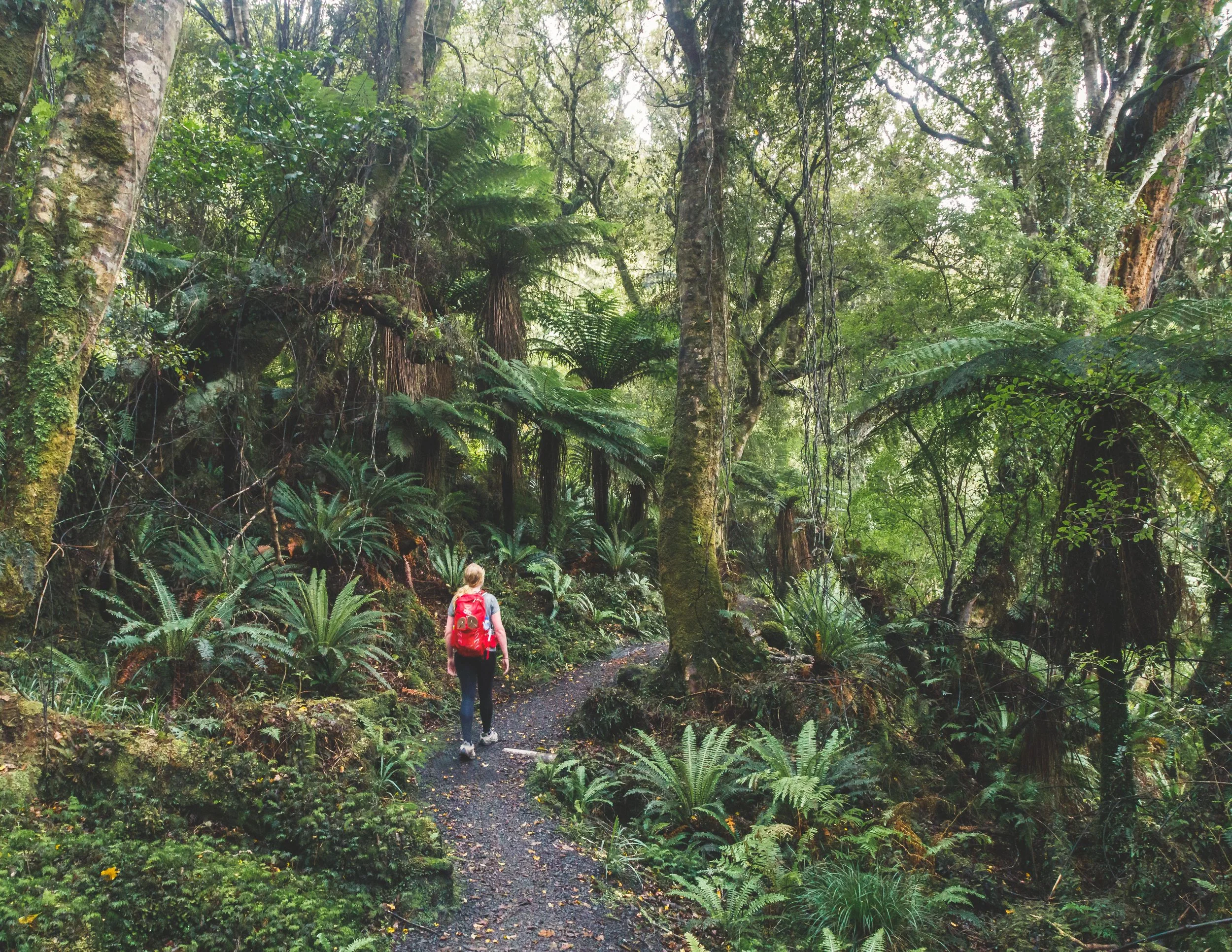
Eventually we reached the top of the hill and soon started descending to Port William hut. At this point of the walk everything was covered in ferns: the ground, the canopy, dead trees, trees that were alive, everything!
The path soon came down to the coast and Port William Hut, a great place to stay for the night. Except we weren't. Our over-confident planning meant we were here for lunch and only a third of the journey done! We had a poke around and the hut and setting were really lovely. We wished we hadn't decided to skip it
However, It was at this point that we also realised there was something missing on the kitchen bench tops. The gas! The Rakiura Track does not have gas like the other walks we had done in Fiordland National Park. Ooops, we really should have checked that, rooky mistake. Luckily for us four guys rocked up just at that moment and brewed us a tea. People on the trails in New Zealand really are the nicest you'll meet. It did mean though that we realised the pasta dinner we had brought was looking less likely and so we decided to skip lunch and keep our cold food in reserve for dinner.
The view from Port William Hut
Day 1, Part 2: Port William - North Arm Hut
Distance: 13.98km
Elevation: 650m
Time taken: 4 hours 30
Back on the trail
Having had tea and a couple of biscuits we soon hit the trail again. The path went up hill, winding back to where we'd originally been and the junction to North Arm Hut. (If you are walking the track in two days and don't have the feeling that you must complete each kilometre of the trail, you could skip the bit to Port William hut and back and save yourself 4km).
The track continued uphill and we passed two big log haulers, remnants of the logging industry that brought many people to Stewart Island. Later that night, we heard a story by the Hut Warden about the local nurse in the early 1900s who would have to hike to this camp and back into town (a 3-4 hour hike each way) to care for any injured workers. She'd do the same journey for days in a row to ensure they were recovering, a pretty impressive feat!
The trail began to descend and we continued to see the forest get denser and denser, to the extent that the path would become pretty dark in places. It all added to that mysterious lost world feeling. It was in these patches where the forest got even more beautiful, with plants, moss, ground ferns and tree ferns everywhere, making the trail feel incredibly wild.
Down to North Arm Hut
The track crossed a river and then began undulating once more, going up and down at regular intervals until the path soon changed from earth and gravel to tree roots. The dense forest suddenly opened up, letting in a golden light from the sun that had now burned through the clouds.
19km in we decided to sit down for a break before tackling the last few kilometres and it was then that we remembered that one of the lovely women we met on the Kepler Track, Jacinta, had given us some scroggin (trail mix) and sweets. Scroggin has never tasted so good, thanks Jacinta!
Feeling revived and before we knew it the path dropped down to North Arm Hut, another stunningly situated hut on the shore looking out to a forested cove. After nearly 23km our legs were beginning to ache, but we were also feeling pretty accomplished! Combining the two days made the trail more challenging, but really fulfilling when we arrived.
An evening at North Arm Hut
We got lucky as a lovely German couple took pity on us forgetting to bring the gas burner, and Pesto Pasta for dinner was back on the menu. We needn't have saved our lunch after all! Following a decent dinner and watching the sun go down, the Hut Ranger took centre stage.
If you've read our other blogs on The Routeburn and The Kepler tracks, you'll know that many DOC Hut Wardens really like to put on a show with these talks, and they are often far more than simply describing safety procedures in the hut and on the trail. Although the North Arm Hut Warden didn't get a guitar out (yep, this happened on the Kepler), he did get top marks for his historical knowledge of Stewart Island.
The view from North Arm Hut
He told us about Rakiura meaning the glowing skies (referring to Aurora Australis, the Southern Lights), Captain Cook thinking it was attached to the mainland, and the original Stewart who mapped out the whole island and had it named after him. He also mentioned that a seal had once gone into the female toilets in the village pub - true story, you can check out the photographic evidence hanging beside the toilets!
Sadly we were too tired to go kiwi hunting, but we'd been told it was a great spot for seeing them in the dark (and sometimes in the day). However, we just crashed at 9pm, satisfied that we'd done quite a few kilometres, climbed a few steep hills and managed to actually have a dinner!
Day 2: North Arm Hut - Fern Gully
Distance: 11.32km
Elevation: 402m
Time taken: 3 hours
After a good night's sleep, we had a swift breakfast and headed back onto the trail again, hoping that maybe we'd see one of those elusive kiwis. The track immediately headed upwards into the forest, hugging the coast.

After North Arm we soon saw some more inlets and beaches that would have been even more stunning on a sunny day. However we'd been greeted with a really thick fog which made the distant islands and coast mystical, but hard to really see!
After a couple of beaches the track went back inland and into the forest once more. It was at this point that I realised that for a lot of the first day and again now I'd been smelling eucalyptus, something that was so fimiliar from our time in Australia and never thought would be here on Stewart Island. A short look up and low and behold, there they were and that beautiful scent had been released from the early morning showers.
As the path gently ascended, the fog got thicker and soon we could barely see each other. In the forest, it certainly felt like a fairytale setting.
Nostalgia
We started chatting about how this was the fourth of our Great Walks and that they seemed to be flying by. We'd only been in New Zealand for four weeks and we'd walked nearly 200km and climbed over 7,000m, something we never thought we'd be able to do a few years back.
We looked back on everything we'd done, comparing it to other trips and what we'd do in the next few weeks. Then before we knew it, two hours had passed and we'd reached the end! Don't get us wrong, we were still appreciating the hike, but the final part wasn't an endurance like the last few kilometres of some of the other Great Walks, it had put us into a relaxed and satisfied mood. So much so that even though we had planned on calling a taxi from the Fern Gully car park at the end of the track, that we decide to walk the two kilometres instead!
If that isn't a ringing endorsement, then I'm not sure what is.
The Rakiura Track Overview
The Rakiura Track is a three day hike (although you can do in two) that can be done by anyone who can manage several hours walking at a time. It doesn't require a high level of fitness, but you can tailor it to be more challenging if you'd like. It's a trail that offers forests unlike any we'd seen in New Zealand and beaches that are little patches of paradise on a sunny day. In fact if you walk it in three days definitely bring your swimsuit as the beaches you pass on day one make for the perfect place to relax, and as the walk is just over 8km that day you would easily have time.
We found that the track was in very good condition with only two small sections of mud. There was a lot of newly laid gravel in a lot of places and the both of these stretches were shallow and just required some tiptoeing around the edge, but were by no means obstacles.
It's a great track to do if you want to avoid the crowds (this has only 24 people per hut, less than half of the Fiordland Great Walks), discover a part of New Zealand that few people get to and if you are lucky spot the beautiful New Zealand icon, the kiwi.
How to plan the Great Walks
North Island
South Island
This post may contain affiliate links, meaning at no additional cost to you, that we will earn a small commission if you click through and decide to make a purchase. This helps towards the costs of running our website. :-)
Like it? Pin it!

Would you hike the Rakiura? Have you ever done something like forget you gas cooker for a camping/hiking trip? Let us know in the comments below.
Featured Posts


How to find the secret Fisherman’s Cave in Royal National Park and what to expect from the walk.