

Maybe it’s the altitude or maybe it’s the stunning views, but the Abbott Ridge Trail mesmerises everyone who takes it on. This incredible hike is hard work and by the top your legs will be screaming, but this is a hike with a BIG pay-off at the end and one of the best in BC.
Whilst everyone is in Banff and Jasper, Abbott Ridge sits in Glacier National Park (the Canadian one, not Montana) and has all of the wow factor and none of the crowds. I think we saw about six other people during the entire hike!
This is one hike that definitely needs to be on your Canadian bucket list.

Planning your hike
Glacier National Park is just over two and a half hours west of Banff and isn’t far from the town of Golden (it’s in the BC time zone, so you’ll go back an hour if driving from Golden or Alberta). The park is famed for some incredibly steep hikes that take you straight to the mountain tops offering unforgettable views of some stunning glaciers.
The Abbott Ridge hike starts from the Illecillewaet campground and you’ll want to allow six hours to hike up, take in the views and take the longer route down. You can probably take an hour off if you want to go fast (we took 2 hours 30 to get to the top), but it isn’t a hike you want to do when you feel pushed for time!
Glacier National Park has a high concentration of bears though, so bring your bear spray (you can buy online for about $50 on Amazon or REI). The Asulkan Valley trail had four grizzly bear sightings in two days when we were there (and it still wasn’t closed!). We’ll detail some bear safety at the bottom of this post.

The Abbott Ridge hike
Difficulty: Hard
Distance: 17km (we used the short route up and long route down)
Elevation: 1067m
Type of trail: Out and back with option to make it a partial loop
Time taken: 5 hours
The trail to Marion Lake
The hike starts by the derelict ruins of Glacier House (like virtually all the trails in Glacier do) and then it gets really steep really quickly! The first part of the trail takes you to Marion Lake and doesn’t ease you in gently.
The track is a series of switchbacks through the forest and is uphill all the way to the lake. At this point we were wondering what we had let ourselves in for. If this was the beginning bit to the lake marked as moderate by Parks Canada, how would the rest of the hike go? Strangely this was by far the hardest part of the trail and must be considered moderate when the whole trail is marked difficult because it is shorter!
Anyway, back to the trail, after a breathless 50 minutes and 3km later, we reached Marion Lake and our lunch stop for the day. The trail is in great condition and it’s definitely the steepness that makes it tough going and not the terrain.

This is a classic Canadian lake - fringed by pine trees, perfectly still and a deep green. It’s pleasant, but if we’re honest it’s not worth the steep climb if you’re not going onwards to Abbott Ridge.
From here the track continues onwards (and upwards) for about 500 metres before your big choice: the long or short route.

Read next: The stunning Joffre Lakes hike - a trail to one of BC’s most beautiful lakes
Long or short route?
You’ll reach a post with a choice of paths, but very little in the way of information to help make a decision! Here’s what you face:
Short: a rocky hike that is pretty steep. The trail involves a little scrambling (not that much though and not difficult) and heads sharply uphill but gets you to the meadow pretty quickly.
Long: if the first 3km have you legs screaming in pain, then go for the long route. It is about 2km longer, but a lot less steep. The path has a couple of narrow stretches, but if you have time and want a break from the steep incline, this is the one for you.

Of the two options, we recommend taking the short route up and then the longer route on the way back. The short route isn’t painfully steep and gets you towards the top quicker. The views are also great and there are plenty of rocks to rest on if you need a breather. For us we think it’s easier to go up the rocky terrain rather than down.
On the way back, take the longer route as you’ll be facing the stunning glacial views all the way. It’s also a nice break for your legs after a long day’s climbing!

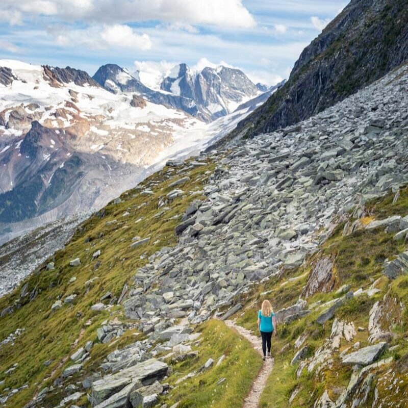
The Meadow
Both short and long trails finish at the meadow: a section where the trees disappear and the epic views begin. Make sure you turn around a few times to see the stunning glacier views behind you as it is a truly special spot.

The path climbs up a small hill before you come to face to face with the switchbacks to Abbott Ridge (which look so much steeper than they actually are thankfully).
You’ll climb up a rocky path through the meadow before you hit the switchbacks. Luckily they aren’t steep and actually make this section of walk feel easy as they are so gentle and have plenty of flat sections to relax on. It gives you so much time to look around and take in the absolutely incredible views, you’ll probably be marvelling at how you can possibly have them all to yourself too!
After a few gentle switchbacks the trail curves behind the ridge and climbs a little more steeply to the top. You’re not far from the true wow factor now!

Read next: Ha Ling Peak - the newly reopened trail in Canmore
The ridge
This is where the truly special section starts (and that’s saying something given the views you’ve already had).
The track winds up to a narrow and rocky ridge, offering panoramic views of the whole park.
You have the feeling of standing on top of the world and one of the best ends to a day hike we’ve ever had.

After around 7km you’ve reached the official trail’s rocky end and the “end of trail sign” - despite the fact you can see a long ridge line ahead! There are some huge flat rocks here which make for an amazing place to sit and take in the views.
We carried on for another 500 metres along the ridge and found the path to be in a good condition and wider than it looked (we’re pretty cautious scramblers).
You’ll start with some easy boulder hopping before there is actually a bit of proper scrambling to do.
It isn’t difficult but it is quite exposed and we wouldn’t have taken it on in bad weather.
It’s not somewhere you want to be in rain or high wind but if you have good conditions it’s the perfect end to an epic track.

There are three peaks from the end of trail sign and whilst you could slowly make your way to the second, we recommend finishing at the first, the summit of Abbott Ridge. The views here are great and the part after this becomes really sketchy unless you are very used to scrambling.

Whatever you do, give yourself time to really take in this special spot. It was a place that genuinely left us speechless.
Read next: Sulphur Skyline Trail - one of Jasper’s best hikes and The Chief hike in Squamish - an epic challenge
The hike down
The trail down is certainly a lot less tiring than the way up, but it is relentless on your knees and legs.
Even with hiking poles it takes it out of you. Luckily the path is in great condition so it isn’t one of those hikes where going down is as tricky as up, there aren’t any slippery sections at all which we were quite surprised about.
Until now the trail has been pointed towards the mountain, meaning your views were primarily behind you. Now the trail will present phenomenal views in front of you all the way to the forest.
From the meadow, take the longer path (it veers right from the meadow). This trail winds around the hillside (it does have a short uphill section) but on the whole it’s gently downwards. You’ll be walking on the edge of a narrow path along the mountainside and we thought it would be a lot easier than going down the shorter steep route.

The longer trail also offers glimpses of the Asulkan Valley, something you don’t see on any other part of the trail.
Soon you’ll meet up with the main trail and begin the really steep descent from Marion Lake. After 14km, much of which is steep, you begin to really feel it (well, unless you’re super fit!) and the last 3km are just about getting down and finishing!
However, you’ll feel a real sense of satisfaction from this hike. It’s a challenge, but really does reward you and is truly one of the most memorable hikes we’ve done in Canada. Plus it’s one of the few amazing hikes in this part of Canada where you won’t be surrounded by crowds along the trail.
Read next: 10 simple Tofino hikes
Essential info about the Abbott Ridge Trail
So overall how difficult is the Abbott Ridge Trail?
We saw the length of this trail and the elevation and thought we were in for a really hard hike. Whilst it isn’t easy it also wasn’t as hard as we expected, mostly because the actual terrain is great and the steepest part of the trail is at the beginning when you have the most energy.
There are also loads of places where you can easily stop for a break if you are worried, give yourself loads of time and make your way leisurely to the top and you won’t regret it.
Read next: The Stanley Glacier Hike - an easy hike with epic views near Banff
Facilities at the Abbott Ridge Trail
There are pit toilets at the trail head but nowhere to fill your water bottle, so make sure you have everything before you arrive.
Bear safety on the Abbott Ridge Trail
Of all the places we’ve been hiking in Canada and the US this area had the most bear sightings by a long way. Whilst there hadn’t been any bear sighting on this particular trail there had been multiple grizzly sightings on the nearby trails, including one incident where the bear followed the hikers for a while which must have been terrifying.
We thought that multiple grizzly sightings over many days might lead to certain trail closures but that wasn’t the case on our visit so please be especially aware of bears in this area. Both grizzlies and black bears frequent it. This is one area that you really should be carrying bear spray (the week we were there someone had to use theirs so don’t forget it!) and be vigilant and make noise around any blind corners. The trails are not as heavily trafficked as many in the Rockies so you don’t have that safety in numbers feeling you get around Banff and Jasper.
There is a white board up by the trail heads where you can note any bear sightings, what type of bear, where it was and any other details. Check this board before you hike. It’s actually why we chose not to hike the Asulkan Valley trail during our visit - four grizzly sightings at close range in two days.
Having said all of that the chances of a dangerous encounter are still very slim, most sightings were of bears eating berries and ignoring hikers. Despite being terrified of bear encounters after having survived one bear attack already, we would still hike in this area again - but not on the trails with recent sightings and always with bear spray.
We strongly recommend buying bear spray before you go. You can get some for about $50 from Amazon or REI (don’t take it over international borders or fly with it, as it’s considered a weapon!). Alternatively, ask your hotel if they have any, as sometimes guests hand it in before they leave.
Read next: The Bald Hills Trail for one of Jasper’s epic hikes
Glacier National Park entrance fee
The Abott Ridge trail is in Glacier National Park and you will need a parks pass. Entry to Jasper National Park costs $9.80 CAD per person per day ($7 USD).
If you plan on visiting multiple National Parks in Canada, you could look at the annual pass. It costs $136.40 CAD ($102 USD) for a whole car and will get you entry to 80 parks in Canada.
Getting to the Abbott Ridge Trail
The Abbott Ridge trail starts from the Illecillewaet Campground in Glacier National Park, Canada. The nearest major town is Golden which is a one hour drive away and it is 2.5 hour drive from Banff. You can also drive from Revelstoke which is only 45 minutes away.
Read more: Johnston Canyon & the Ink Pots Hike - a must do in Banff
Where to stay in Golden
Pinewood Inn
Cosy 1 bedroom suites with mountain views? Sounds idyllic for a BC getaway, especially if you plan on doing the kind of hiking we did!
The rooms are stylishly furnished, in a great location and have their own kitchens, which means you don’t have to leave!
This post may contain affiliate links, meaning at no additional cost to you, that we will earn a small commission if you click through and decide to make a purchase.
This helps towards the costs of running our website. :-)
Like it? Pin it!

Follow us on social media
Are you planning a trip to BC? Would you take on the Abbott Ridge trail? Let us know in the comments below!