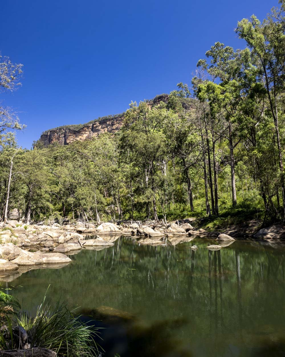
The Capertee River is gorgeous, with clear water and steep mountain backdrops, not to mention abundant secluded swimming holes. It’s the kind of place you can visit on a hot sunny day in summer and still never see another soul once you leave the campground behind. Wildlife is everywhere and we were lucky enough to see kangaroos, wallabies, goannas, kingfishers and a Gang gang cockatoo right in the middle of the day.
Though there are many places from which you can explore the river, we opted to begin at the Coorongooba campground, one of the most beautiful in NSW.
The trail we’re describing in this guide isn’t an official walk as such, but a makeshift route to a beautiful riverside swimming hole.
Here’s how to find it.

The Capertee River Walk
The stats
Distance: 5.8km return (but you could shorten it if preferred)
Elevation gain: 100m (or more if you take the fire trail both ways)
Difficulty: Easy - moderate, depending on route taken
Summary: There are several potential swimming spots on the Capertee River, but we’re going to focus on our favourite, which we’ll be referring to as ‘the main swimming hole’.
There are two possible ways of reaching the main swimming hole on this walk: the easiest version predominantly uses a fire trail, only cutting down to the river when necessary to access the pool.
This route has some elevation gain and some short rocky sections when moving from one pool to the next (if you choose to visit more than one), but it’s generally easy with good track conditions.

The second route is via the river itself (there are a few places where you can cross from the riverside trail to the fire trail, so it’s possible to use the fire trail one way and the riverside route the other to form a circuit).
Some of this is easy walking along the river banks or in the shallow river itself (it’s shallow in all but extremely wet conditions). This is the one to take if you want to visit all four water holes, but there’s a catch.
To get to the swimming spots via this route requires significant scrambling over boulders and on overgrown bush ‘tracks’ - there are no real tracks, it’s definitely a bush bash.
The riverside route is of course more scenic, but much slower going and more challenging. It does reach two pools that you won’t see from the fire trail, but you need to be up for a harder walk.
There is no phone signal in this area and once you leave the campground it’s pretty remote, so you may want to carry a PLB, particularly if you’re hiking alone and taking the riverside route rather than the fire trail.

Starting the trail at Coorongooba campground
I am going to start the notes using the fire trail route because I think this will be most people’s preferred option. Although you could simply walk along the fire trail the entire way to the main swimming hole, this does involve walking up and down one long steep hill and misses out on a beautiful part of the river.
For this reason my recommendation would be to predominantly use the fire trail, but not from the very beginning.
The first 750m of the riverside track was gorgeous and if I’m entirely honest, the only part of the riverside route I enjoyed. At the 750m mark you can then cut across onto the fire trail.
Although we do a reasonable amount of off track walking, I’m not a huge fan of it, I just don’t want to miss out on beautiful places. If there’s an easier route I will always try and find it!
So if you’re like me and you fancy doing the easy bit of the riverside walk and skipping the big fire trail hill, then read on.

If you’d rather take the fire trail the whole way, park at these coordinates: -33.124735, 150.323211 (a minute’s drive away from the riverside route start point) and head straight onto the fire trail, which goes steeply uphill immediately.
You can skip through our trail notes until the section where the riverside route meets the fire trail.
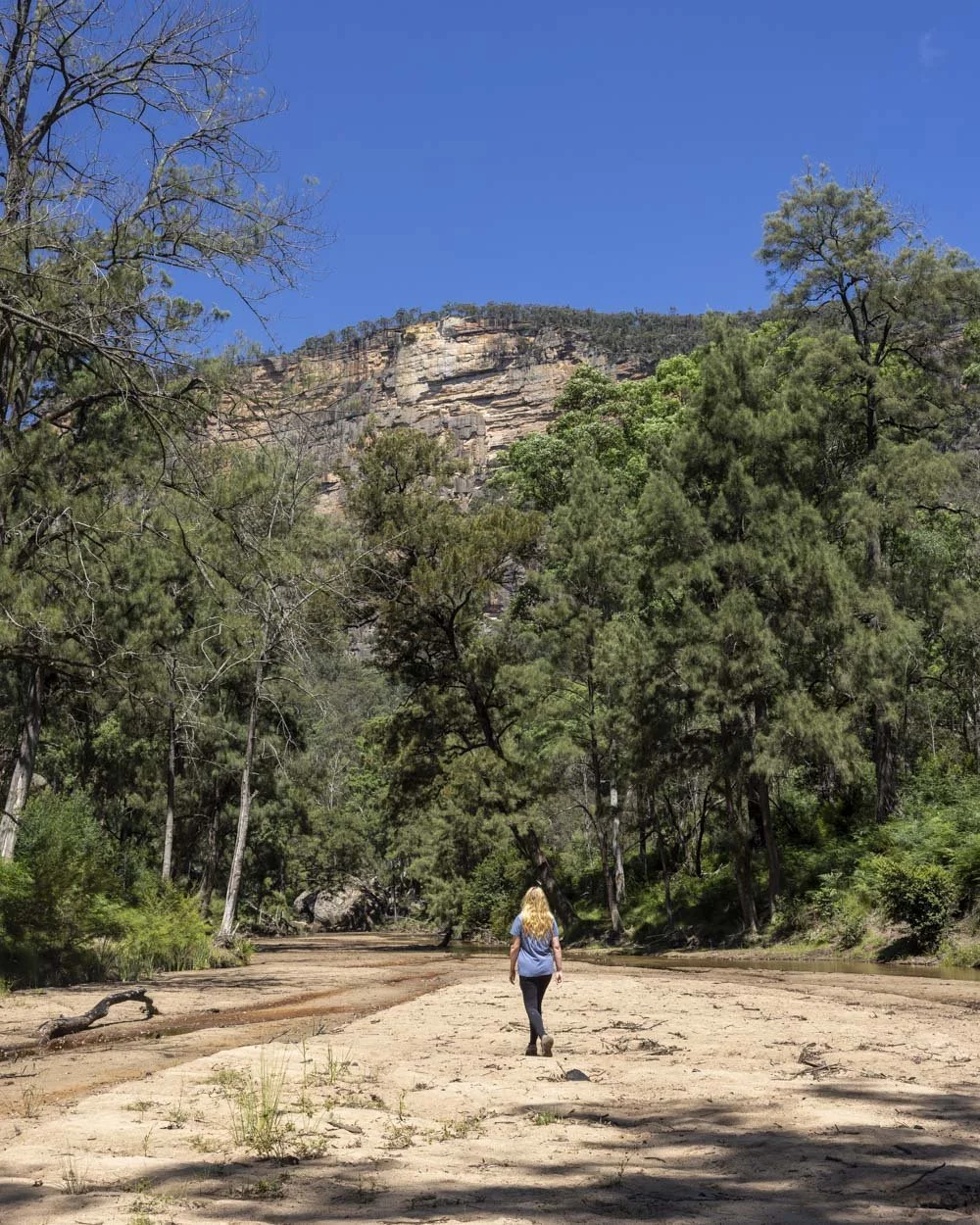
Heading along the river
To begin on the riverside route, park at these coordinates -33.125642, 150.324439 (it’s the furthest end of the campsite you can drive to) and look for the gap beside the orange post, where a trail leads down to the river.
It’s a sandy track which reaches the river after just a minute.

In all but flood conditions this part of the river is very shallow.
From here you have two options, head along the defined path on the river bank on the right (western) side of the river (do not cross the river). Or take your boots off and simply wade through the shallow water downstream. Joe went for the riverbank option and I went for the wading option.


Whilst there is a path running alongside the riverbank, it’s often narrow and a touch overgrown. I much preferred simply walking through the ankle deep water, which had a nice sandy bottom and no slippery rocks - the perfect wade!

I saw so many kangaroos on the little beaches, they would bound across the water when they saw me, one of the many delights of the first part of this walk (you’d still see them from the riverbanks, but it was fun to be down at the water with them).

You’ll follow the river downstream for 750m no matter which path you want to take.
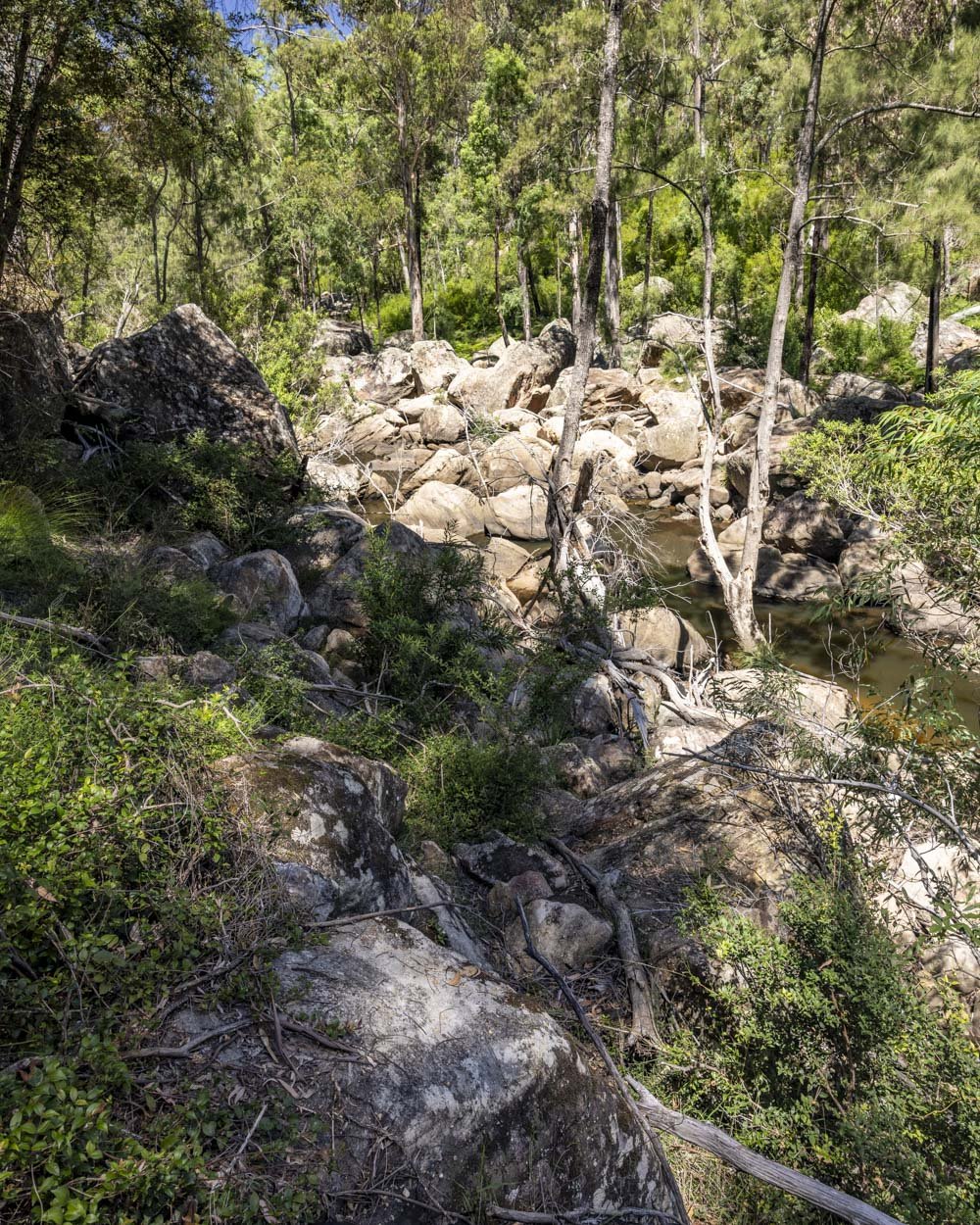
If you’re taking the riverbank route, you will reach some eroded sections after 450m and the dirt track will undulate. It can be a little rough, but it’s always easy to follow.
After approximately 750m you need to look for a gully on the right side of the river. This is your route onto the fire trail.

The very first bit of this gully is heavily eroded and if you walk along the side of it, take care as it just crumbled from underneath me - though it wasn’t dangerous as it was just like slipping down a sand dune.
You can avoid walking on the crumbling bit by simply wading through the middle and climbing out at the end, rather than walking up on top of it, though this has slightly deeper water which was a bit foamy and unpleasant.

After around 1m or so you will walk onto a very stable part of the gully, basically a dried up creek bed and follow it for around 150m. At this point you will join the fire trail and head left (approx 900m from the campground).

Along the fire trail
The fire trail is wide and in excellent condition. It’s pretty much flat at first, or so gently uphill as to almost feel flat.
It runs parallel to the river, though you can rarely see it. The mountain views however, are absolutely stunning.

The part of the river that you’re walking parallel to is no longer the shallow scenic section you’ve walked through or beside to this point. It’s wide, deep, and not overly pleasant, with brownish water covered in debris.
After 500m on the fire trail you’ll see a very obvious path on the left. This leads down to the far end of the brown pool, where the boulders start and the river narrows.


Continue along the fire trail and after another 250m it will start to head noticeably uphill. It’s quite steep for 150m before it flattens again.
A couple of hundred metres later you will descend a little before the path flattens again.

After 200m of flat track (2.4km into the walk or at these coordinates -33.138899, 150.333530, as the route exclusively using the fire trail may differ in length), you will see a social trail leading downhill to the left.
After 50m on a good path you will reach the main swimming hole of the walk.

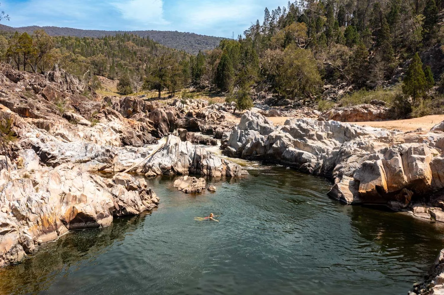
The main swimming hole
Unlike the brown pool, the water here is clean and inviting. The emerald water shimmered in the afternoon sun and the mountain backdrop made it all the more special.
Accessing the water is easy due to the sandy bottom and lack of rocks.

The pool is large and has a great amount of space for a proper swim, but do watch out for debris as there are several trees inside the water, more around the edges though, so I stuck to swimming in the middle part of the pool.
The water was surprisingly warm when compared to the majority of swim spots in the Blue Mountains, though still what most people would probably describe as refreshing!


Continuing along the river to ‘Look But Don’t Touch Pool’
There’s an absolutely spectacular pool a little further along the river. Once you get there, you’ll understand why we’ve named it ‘Look But Don’t Touch Pool’.
Though it’s one of the prettiest pools you can imagine, hemmed in by boulders with a towering mountain in the background, the bottom of the pool is muddy.
And I don’t mean a bit muddy underfoot because that wouldn’t bother me, I mean clumps of mud that dislodge when you move and then proceed either to stick to you, or disperse in the water making it look grubby.

There are also a lot of large rocks in the water which are hard to spot due to the aforementioned soil dispersal.
I would absolutely recommend heading on to see it, but not if your sole intention is to swim.
Assuming you do want to visit, you can reach it by walking on either side of the river. It is approximately 450m beyond the main swimming hole, though it is likely a bit less as our watch struggles to measure accurately on this kind of terrain.
The left side of the river involves walking along some grassy, sandy and rocky sections.

It’s possible to go barefoot, but it’s a bit slow going and some of the rocky bits are a little uncomfortable. There isn’t any tricky terrain, but there is no formed path. Just before the pool you will have to climb across several boulders, but it’s grippy when dry.
The route along the right side of the river has two options: the first is to stick to the riverside and scale the rocks. There’s a short break when you walk along a pebbly beach before it’s back to rock hopping again.

The other option is to head back to the fire trail and turn left. The fire trail will then cross Freshwater Creek and continue onwards for 350m before you can hop over some rocks to get to the final pool.

Once you reach the small pool it’s a stunning spot to relax on the rocks and enjoy the incredible views.

Though you could no doubt head further up river from here, we chose to turn around at this point. You can either head back along the riverside route and turn onto the fire trail (on the western bank) at the earliest opportunity, or take the riverside route all the way back.
If using the fire trail, at the point at which you would turn right to the gully to reach the river, there is another big hill (that initial big hill from the campground goes up then downhill), so you can either tackle the hill or head back onto the riverside route at the gully.
The riverside route and extra swim spots
If you want to do the full riverside route, you would start as mentioned above, with the first 750m either wading through the shallow river, or walking along the riverbank.
You can do this on either side of the river. I personally think the right side of the river (ie not crossing over the river) was the easier side and this is what I would recommend.
Both sides do involve significant scrambling over boulders, which gets more rough and challenging the further you go. It’s best done on a dry day when the rocks are grippy. There are also sections through the bush with no path.
This is a scenic route, but definitely slower and more care is required.
From the point at which you can no longer wade through the river, or 750m into the track, you will begin walking along the riverbank on the route that looks easiest to you and the inevitable boulder scrambling. Around 600m later you will come to the first sizeable pool with clear water.
This pool is long and pretty, but shallow and has both rocks and logs in the water. Good for a little dip or paddle, but not for swimming.

The next pool is around 300m further on, we called this the ‘Cliff View Pool’. You need to climb over some boulders to enter the water and it looked shallow, so better for a plunge than a swim (though I personally didn’t swim until we reached the main pool mentioned in the notes above).

Cliff View Pool
The next pool is around 450m further on and we named this one ‘Boulder Pool’. It’s quite large, but you do need to get through some significant tree fall and boulder scrambling that make it a little tedious to access. We’re also not sure about the depth of this pool.

Both Cliff View and Boulder Pool are really pretty, but may or may not be good for a swim depending on depth and debris in the water.
Boulder Pool
Boulder pool is only 200m from the main pool I swam in and getting to the main pool is a lot easier than the trail has been up to this point. Though the distances between all the pools sound really short, it’s slower than you would expect due to the nature of the terrain and the sheer amount of debris.
Once you’re at the main pool you can continue on as mentioned in the notes above. From Look But Don’t Touch Pool you can either retrace your steps along the river, or head onto the fire trail for an easier walk back.

Keep them wild
Please remember to take all rubbish with you and keep these places wild and pristine - as with anywhere in the outdoors. It’s important to leave them exactly as you found them so they will remain beautiful for generations to come.
Litter tends to breed litter, so if you do spot any and are able to pick it up and dispose of it outside the area, it will go a long way to keeping the area clean.
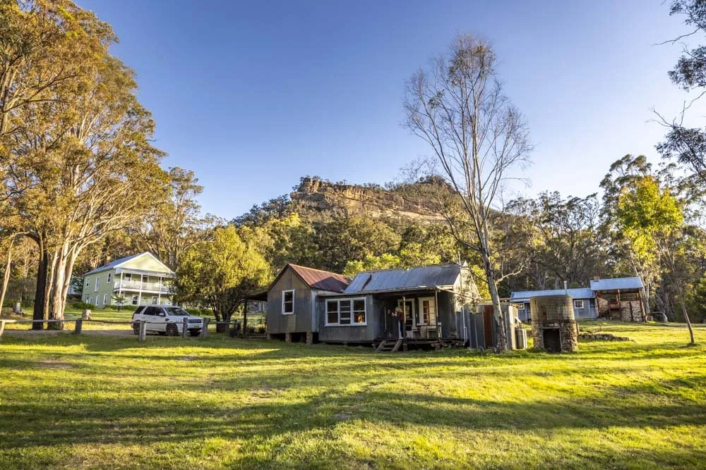
Coorongooba campground
Coorongooba campground is spectacular, one of the best we’ve seen in NSW! It’s huge, so even when busy, it should be easy to find a secluded spot. Though late afternoon you’ll definitely have to share with space with the resident kangaroos and goannas!
There are several long drop toilets, picnic benches and BBQ facilities, but you’ll need to bring your own drinking water.
The campground is free, but a $6 booking fee applies to secure your spot online, which you can do via the national parks website.

Getting to the trailhead at Coorongooba campground
The last 5.2km of the road into the campground is unsealed (gravel). There is a small ford roughly 2.2km before the campground. Any car can manage the road and ford at time of writing, it was very well graded and the ford had barely an inch of water (but would be impassable during extreme rain).
The drive into the campground is simply sensational, you’ll want to have your camera at the ready. If driving out in the late afternoon or early morning watch out for kangaroos and wallabies on the road, of which there were many.
The campground is 58km and a 50 minute drive from Rylstone, 120km and 1 hour 45 minutes from Katoomba and 220km and a three hour drive from Sydney CBD.
This post may contain affiliate links, meaning at no additional cost to you, that we will earn a small commission if you click through and decide to make a purchase. This helps towards the costs of running our website. Thanks for your support.