The walk to Bundanoon Creek has to be one of the most underrated in the Southern Highlands. The scenery is spectacular and there are swimming spots galore. The walk to the creek alone would be one of the best walks in the area, but it gets better.
There’s also a hidden canyon waterfall with an ice blue plunge pool at the bottom. We couldn’t believe it either.
Somewhere this special doesn’t come easy and there’s a steep climb in and out of the gorge to tackle, but the reward is more than worth the effort.
Here’s everything you need to know about the Bundanoon Creek walk and how to find the hidden waterfall.

The Bundanoon Creek Walk
The stats
Distance: 4.4km return, including the waterfall side trail
Elevation gain: 335m
Difficulty: Moderate
Summary: The walk down to the creek is all on a maintained track, but it is steep. Short sections are next to an exposed drop which wouldn’t go down well with vertigo sufferers. However, the majority of the walk is not exposed.
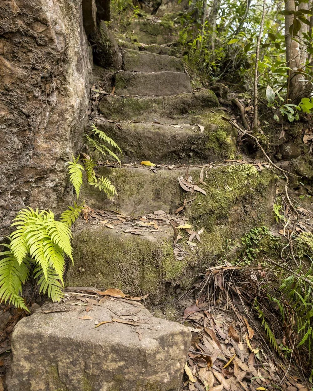
There are minor sections which feel a touch slippery, but again, the majority is ok, so if you’re like me and not fond of that kind of terrain, just take it slowly. The track is a mix of good dirt path, uneven stone stairs and some rocky bits.

Once you get down to the creek the formed path ends and to continue to more swimming spots (though there is a swimming hole at the end of the maintained path too) you need to go off track. It’s not far, but it’s a little bit of a bush bash - though a pretty easy one.
Accessing the hidden waterfall requires climbing up some rocks and negotiating one narrow ledge which is exposed. It’s only a few steps, but requires care and it is not recommended after heavy rain when the cascades would be running powerfully and it could be dangerous.
Even without the waterfall the track is fantastic, so if you don’t like the look of it, the walk will still have been worth it.

Starting the trail
The walk begins at the parking area for Tooths Lookout (full parking details below) and heads onto the smooth flat path between the gum trees.
After 150m you’ll reach Tooths Lookout, a railed viewpoint offering a gorgeous look at the mountains and forested valley below.


After this point you will pass a sign stating the track gets steep, this is after an initial sign at the beginning of the walk saying that it’s not for the faint hearted! It is steep, but it’s half the elevation gain of trails like Perrys Lookdown in the Blue Mountains, so I wouldn’t be too alarmed!
I was honestly expecting much worse based on the signage.

The start of the trail is a mix of dirt path and uneven stone steps, which are grippy when dry. I would not walk this trail directly after rain as the steps could become slippery.
The scenery is gorgeous with stone walls, distant mountains and plenty of pretty gum trees.

The path is narrow and at times early on in the walk, it has some exposure to the left. The drops are quite sheer and might be worrying if you’re not a fan of heights. It’s not really narrow, or really exposed, but enough that I think it’s worth mentioning.

The descent continues
After 500m the trail starts to zigzag down the cliffside. Again, early on some of these zigzags are a little steep and I was happy that it didn’t continue like this all the way to the creek.
The dirt path soon has some stone steps again and after 250m the gradient slackens and it gets much easier.

You’ll walk through some beautiful ferny sections and can relax now that there is no exposure whatsoever. At the 850m mark you’ll reach a junction with Nicholas Pass, which is to your left, opposite a derelict trail sign.
I believe this would take you to Fairy Bower Falls, which if you haven’t been would make a lovely alternative route back - though I can’t comment on the state of the track as we haven’t visited the falls from this direction before.


From the junction you’ll continue straight and the next 400m are on a good track and much more leisurely. There are a couple of steps of steeper track after this, but literally a couple of steps before it’s gentle again for the next 150m.
At this point you’ll reach the final part of the descent, which is steep, but it’s not exposed and the grippy rocks make it pretty easy.

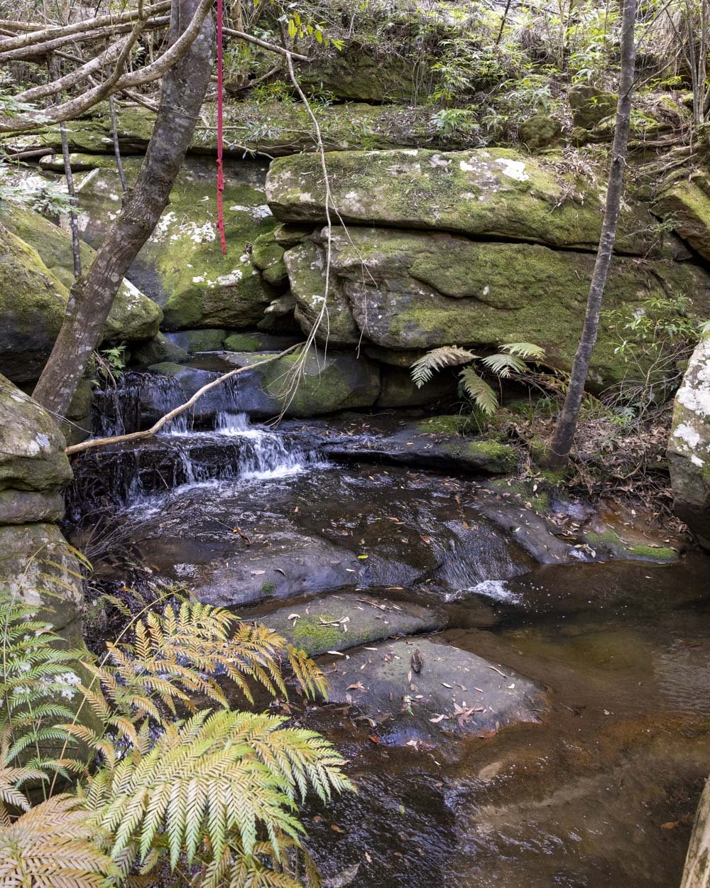
There are a couple of hundred metres of this steeper rocky track before it all but flattens for the final 100m to the creek. The creek is so pretty, with tall gorge walls and deep green water.
There are plenty of large boulders where you can sit and relax before deciding if you want to continue a little further along the creek.

Exploring the creek
The initial part of the creek you come to is lovely in its own right and I originally planned to swim here. There’s a large pool, which though we didn’t personally test out, looked great for a refreshing dip.
In the end exploring the creek and stumbling upon the hidden waterfall took up so much time we couldn’t squeeze in a swim here too - one for next time!

To continue along the creek you first need to cross it. There are plenty of rocks and boulders you can use to do so without getting wet boots and the rocks were generally grippy, but tread carefully anyway.
From the maintained walking trail that ends at the creek it’s just 250m to the hidden waterfall. It could be a little less as the next portion is off track, so we went back and forth a little looking for the best route.


Once you get to the other side of the creek there is quite a lot of debris, but you can get around it without too much bother.
You’ll see a small overhang and there’s a shallow creek crossing just down from here. This creek crossing is a matter of a few steps and it’s very shallow, but the wet rock is banana skin slippery, so try not to touch any of the wet rock.

Then continue through the bush, which is straightforward, though there is no set path. There are some rocks and tree roots, but no tricky terrain.

You’ll pass an opening inbetween two large rock walls/boulders which provide access to a particularly scenic part of the gorge and another potential swimming spot.
It really does get even more special along here, with the high gorge walls giving it such a dramatic feel.


Continue a little further through the bush and you will see another opening to the creek, with rocks you can use as stepping stones to reach the other bank. To get there, you have to walk slightly downhill, but it’s not steep and the terrain is not challenging.
This is around 200m from when you left the formed walking track on the other side of the creek.

The coordinates for the creek crossing are -34.6843413, 150.3100883. This opening to the creek is another superb swimming spot and the entry point for finding the hidden waterfall.
Swimming at Bundanoon Creek
This part of the creek was a glorious place to swim and there was easy access to the water to the right of the rocks which avoided any slippery terrain. The water is shallow at first and then quickly deepens.
Once in the deep part of the pool it was totally unobstructed, I didn’t bump into any rocks and could relax and take in the epic scenery.

The craggy gorge wall and giant boulders really added drama to the scene and I felt tiny swimming beneath them. The water was a deep green and though cool, didn’t feel overly cold on a warm day. We sadly missed capturing light on the water in our photos, but before the sun hid behind a cloud it was shimmering.
I absolutely loved swimming here and would have explored far more of the swimming spots on the creek if we didn’t hear the nearby cascades….

Finding the hidden waterfall
Co-ordinates: -34.6840526, 150.3100112
One of the many wonderful things about swimming at the creek is the sound of the nearby cascades, which happened to be really loud at this last swimming spot. And that’s because just up from here lies a huge canyon waterfall.

On the northern side of the creek, across the ‘stepping stones’ you will have seen when you first arrived at the swimming spot, you’ll see an opening into the gorge and a set of cascades.
You can choose either to follow the cascade up through the water, taking care over the rocks which can be slippery in places, or clamber up the bank on the left side of the cascade.
Both routes will take you to the foot of the cascades after just a minute.

This last bit to the falls is probably only 20m or so, but it is the trickiest bit and requires care. You may be tempted to keep going through the water, but this would be quite challenging as the cascades get larger.
To get to Fairy Canyon Falls, you need to climb up the rocky wall to the right of the cascades. This is tiered and easy, requiring no technical moves, just watch out incase it’s slippery (though it wasn’t on our visit). You’ll climb up two tiers (basically two to three steps) and see a tree to the left.

You need to keep quite close to the water, so don’t be tempted to take a path that looks like it heads too far uphill away from the water. Clamber around the tree and follow the ledge above the cascades.
The next few steps are along a very narrow ledge which has a drop down to the cascades on the left. There are decent foot placements, but please be very cautious as there is a slip risk here and a slip would not be good.

Don’t rely on the tree to bear any weight, as trees can become unstable and weak over time and you don’t want it to give you false security. Take is slowly and carefully and it’s probably around five steps before you’re on a normal stable piece of ground with no exposure.
Carefully cross the creek here (it’s a tiny crossing of just two steps) and then continue a metre or so further to the bottom of the falls.
There is debris sitting in front of the falls unfortunately, but you can still get a good view from outside the water. Getting into the pool offers by far the best views though.
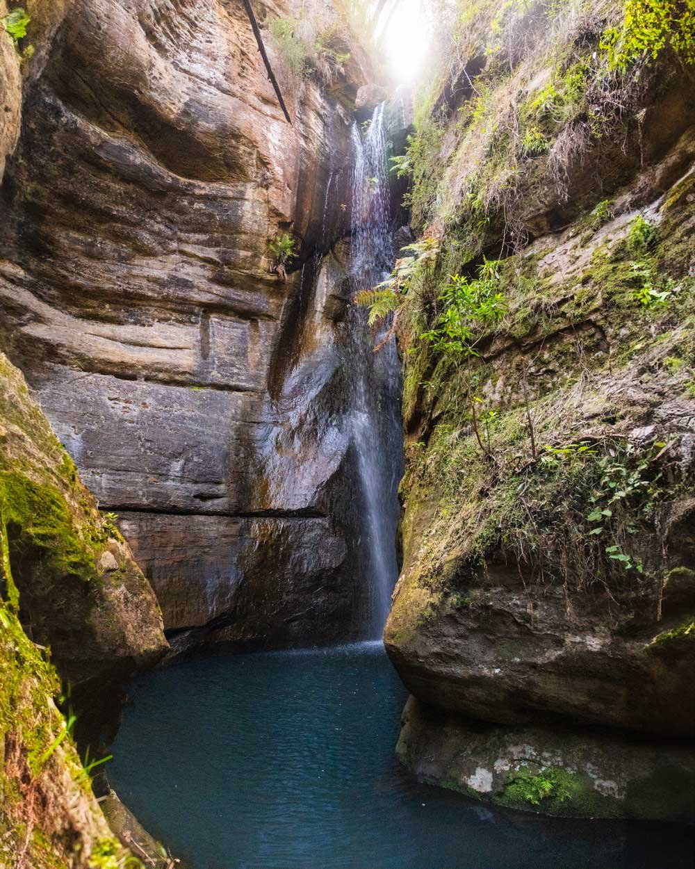
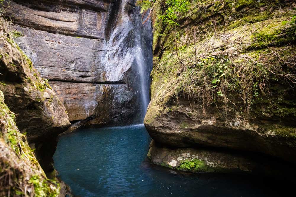
Fairy Canyon Falls
We haven’t seen a name for this waterfall anywhere, so as it sits below Fairy Bower Falls - but is very much in a small canyon - we decided to name this waterfall Fairy Canyon Falls!
It’s incredible and we’re not sure how it’s not more well known - we did notice a rope, so it must be known to abseilers, but we’ve never heard it mentioned by a walker before. I love that it’s still possible to find hidden spots like this within a couple of hours of Sydney!

The waterfall flows into a narrow canyon and forms a stunning icy blue plunge pool at the base. I imagine the water colour is even more amazing in the sunshine, though it still looked great despite the fact it was overcast.
Though you can see the waterfall without getting into the pool, the walls mean that you can’t see it in its entirety. Once you get into the pool and round the corner it’s a truly wow moment.


There is some debris to negotiate getting into the pool, but once inside it was smooth sailing and very deep, so you could have a little swim.
The water is very cold, it matches the ice blue colour for sure, but I loved it! The spray made it hard to get photos inside the pool, so the true majesty will only be revealed when you see it for yourself!

When you’re ready to leave the falls you retrace your steps the same way. Take extra care along the narrow ledge here, as I think it’s slightly more difficult in this direction as you’re going fractionally downhill.
The walk back up to the car park is steep in sections, but not as bad as I thought it would be. There are plenty of rocks to sit on along the way if you need a break.

Keep them wild
Please remember to take all rubbish with you and keep these places wild and pristine - as with anywhere in the outdoors. It’s important to leave them exactly as you found them so they will remain beautiful for generations to come.
Litter tends to breed litter, so if you do spot any and are able to pick it up and dispose of it outside the national park, it will go a long way to keeping the area clean.
Getting to the Bundanoon Creek Track
The Bundanoon Creek Track begins at the parking area beside Tooths Lookout in Morton National Park, which is just outside Bundanoon town centre. There isn’t much room to park, but this isn’t a popular track, so you shouldn’t have trouble.
The last few kilometres of the road to the parking area is gravel, but it’s in good condition at time of writing and any car can do it. There are no facilities at the parking area or along the trail, but you can find long drop toilets nearby at the Gambells Rest picnic area.
This post may contain affiliate links, meaning at no additional cost to you, that we will earn a small commission if you click through and decide to make a purchase. This helps towards the costs of running our website. Thanks for your support.