

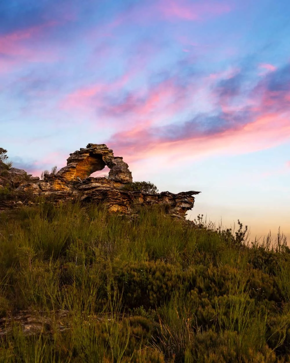
The phrase ‘small but perfectly formed’ could have been coined especially for Mirrorball Arch. And though on the miniature side when it comes to arches, it’s nevertheless quite wonderful and a bit of a novelty to see one so small. It sits on the edge of a cliff with some seriously good views over to Walls Lookout and Rigby Hill that take on a soft golden glow during sunset.
The walk to reach the arch is not on a maintained track and has no signage, but it’s not difficult.
Here’s how to find it.

The walk to Mirrorball Arch
The stats
Distance: 3.7km return to Mirrorball Arch (plus 600m return for the extra viewpoint)
Elevation gain: 120m
Difficulty: Easy - moderate
Trailhead: Bells Line of Road Layby
Summary: The walk to Mirrorball Arch begins on a narrow bush track which is relatively flat and easy. You will then come to a short rocky descent before following another dirt track which has a few rocky sections and a little bit of loose soil. However, it’s not especially steep and has no exposure.
Starting the trail
The walk begins at a large layby on the Bells Line of Road. Unfortunately this means the first 100m are along the highway, but you can keep behind the crash barriers for the most part.

You do need to cross over the highway as the trail heads into the bush on the opposite side of the road to the layby, but there’s never a constant stream of traffic here.
You’ll see a narrow worn path leading into the bush and follow it slightly uphill before it flattens.


There’s bush on either side of the track, but the first 500m are not too overgrown. At the 500m mark you have a 330m stretch of somewhat overgrown track, but it’s not at foot level, so the path is always easy to follow.
It can be a little scratchy but it’s otherwise a very easy walk. There is a touch more overgrown track 100m later but it’s minimal.

At the 1.2km mark you’ll emerge from the bush and get your first look at the stunning mountain vistas - although it only gets better from here.
The track will now gradually descend for a short time before flattening and reaching a fork 200m later, or 1.4km into the walk.


A quick detour to an amazing viewpoint
Coordinates: -33.5796456, 150.3460366
At the fork you could turn right to head directly to Mirrorball Arch, however, if you have a little time to spare we highly recommend making a quick detour.
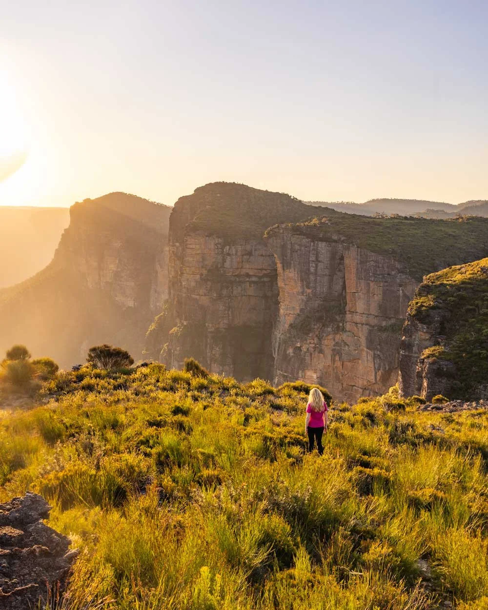
Just 300m from the fork is an incredible viewpoint you really don’t want to miss. Take the left fork and follow it for 20m at which point you briefly re-enter the bush.


Keep following the worn path as it emerges to open views and gently curves left and descends towards a rock platform.
There’s a great swirly rock formation here. From the swirly rock head directly downhill to the left along the very narrow goat track.

This track is a touch loose in places and requires care due to the drop on the right side. You can already see your destination from the swirl, it’s the rocky knoll which is 100m away.

Pick your way down the goat track to the knoll and take care as it’s an unfenced cliff edge.
The view from the knoll is simply sensational. You’re surrounded by mountains and cliffs in a dramatic panorama so good you can’t believe it’s not a named lookout.

There’s room enough to sit and take it all in from the rock platform before you head back to the junction and continue to Mirrorball Arch.
Continuing to Mirrorball Arch
Coordinates: -33.5785991, 150.3421116
Once you arrive back at the original fork in the track you now take the path on the right (though it will be on your left if you’ve gone to the viewpoint). It will almost immediately bring you to a slanted rock platform which you can easily climb down (don’t attempt when wet).


There’s a less steep route to the right if you prefer a shallower descent, but the rock is nice and grippy when dry.
There’s a bit of a gap at the bottom of the rocky route, but you can easily slide off the rock onto the dirt track below.

On the way back up if it feels like too much of a leg stretch, use the shallower route which will be on your left when heading back uphill.
Follow the worn trail leading into the bush for 150m at which point you come to a junction. Head left here and then right 50m later at the next fork.

This track will take you all the way to the arch, which is 250m away. It’s downhill at first and a touch steep and rocky in parts, but not difficult.
If it’s been very dry watch for the loose soil which can be slippery. After descending, the path will curve left and flatten for the final stretch to the arch. The views along the flat section are sensational.

Mirrorball Arch
It’s hard to judge the scale of the arch in photos so you may be surprised at how small it is. But it’s almost more charming and novel to find such a small yet perfectly formed arch.

It’s perched on a cliff edge surrounded by some of the most stunning views you’ll find anywhere in the mountains.

There’s just enough room to sit under the arch and watch as the sun drops below the ridgelines of the distant mountains.

We got so lucky here on our most recent visit with glorious soft light, and then to add even more wow factor, three people base-jumped from Walls Lookout just ahead of us. It was definitely a Good Friday to remember!
When you’re ready to leave, simply retrace your steps back to the car park. We left in the twilight and had just enough time to get back to the car before it got properly dark.
Keep them wild
Please remember to take all rubbish with you and keep these places wild and pristine - as with anywhere in the outdoors. It’s important to leave them exactly as you found them so they will remain beautiful for generations to come.
Litter tends to breed litter, so if you do spot any and are able to pick it up and dispose of it outside the national park, it will go a long way to keeping the area clean.
Getting to the trailhead for Mirrorball Arch
The walk begins from a large layby off the Bells Line of Road - it’s 10.5km east of the junction with the Darling Causeway in Bell. You can find it at these coordinates: -33.568445, 150.349587
It’s around a 40 minute drive from Katoomba and a 25 minute drive from Bilpin.
This post may contain affiliate links, meaning at no additional cost to you, that we will earn a small commission if you click through and decide to make a purchase. This helps towards the costs of running our website. Thanks for your support.


