The view from the top of Mount Dewar is extraordinary. We had no idea what to expect from this hike with next to nothing written about it online - which is hard to believe when it turned out to have one of our favourite views in all of Queenstown!
It would be beautiful at any time of day, but when the sun sets directly behind the series of spectacular snow-capped peaks, it is truly magical. The walk - although uphill - is on a well formed track and relatively easy. It’s also an extremely quiet track so you’re likely to get the view all to yourself.
Here’s exactly what to expect on the Mount Dewar Track.

The Mount Dewar hike
The stats
Distance: 7.6km
Elevation: 500m
Difficulty: Easy-moderate
Summary: The walk up to the top of Mount Dewar isn’t too hard, but it is uphill the entire way. It took us about an hour to hike to the top from the Skippers Lookout car park, so if you want to watch sunset, we recommend getting to the car park about 1.5 hours before sunset.
Starting the trail at Skippers Canyon Lookout
As you drive the long winding road up the canyon from Queenstown, the views are already great. You could be forgiven for thinking that you don’t need to actually do a hike here when the main lookout already offers quite the vista, but trust us, it’s nothing to what you get from the top of Mount Dewar!


If you don’t have a rental car, you can drive to the actual trailhead, 550m from the lookout. Unfortunately, as it’s a steep gravel road, rental cars are not insured to drive it, so it’s best to park at the lookout and walk.
It’s uphill, but not particularly steep and doesn’t take long. There is no pavement though and it’s windy so just watch for cars - we didn’t see any at sunset but imagine it is more popular during the day time.

The climb begins
After walking for just under 10 minutes, you’ll see a DOC sign on the left, just before the warning sign for Skippers Canyon. This is the start of the trail.
The trailhead doesn’t actually mention Mount Dewar, it’s marked as the Atleys Track.


Mount Dewar is located directly along this track. It’s a wide gravel path, much like you’ll find on the more famous Roys Peak in Wanaka.
It begins heading uphill immediately and doesn’t really flatten at any point, but the sloping switchbacks prevent it being too much of a grind.

We were hiking in winter though and late in the day which makes it easier, the route is completely exposed so on hot days it will feel much harder.
The first kilometre is shallower than the rest but none of it is awful.


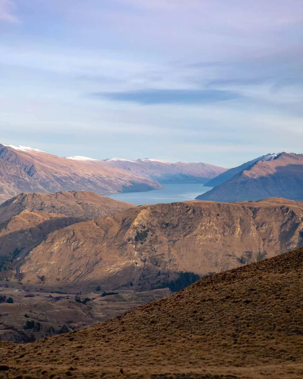
As you climb your views over Queenstown and Lake Wakatipu get better and better. You’ll pass a small tarn which was frozen on our visit, but really it’s all about the big views. Remember to also look back because the view is amazing, looking directly to Coronet Peak.

Getting to the peak
The switchbacks continue, and after a while you’ll start to see the phone masts which mark your end destination.
The track does get a little steeper towards the peak but you can already see where you have to get to and it doesn’t look too far away, so it’s easy to keep motivated.

As you round a corner you’ll start to get different views of rolling hills and ridgelines and it made us vow to come back and complete the full Atleys Track next time. It looks like an incredible trail.

At the 3.1km mark you’ll see a trail directly ahead of you as well as one off to the right. The short (120m) unmarked trail to the right is the one that takes you to the top of Mount Dewar.
The top of Mount Dewar
Now, the one blight on the Mount Dewar hike is the phone masts at the top. Unfortunately they do rather take away the wild feeling of the landscape and it seems a shame they are in such a beautiful spot.


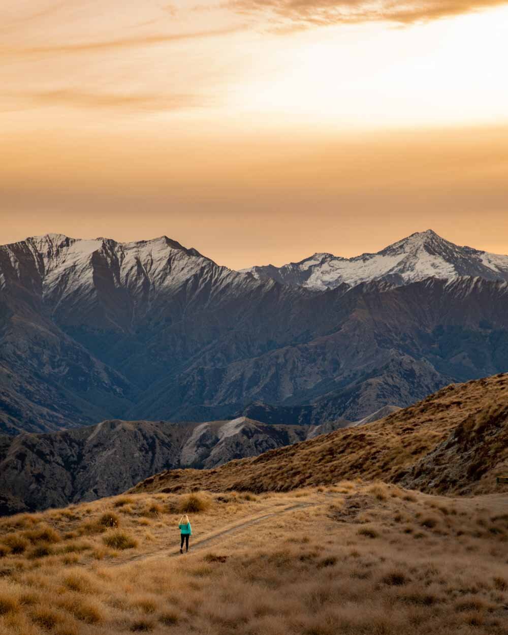
Having said that the view is so incredibly spectacular that you will let that go. All you can see is layer upon layer of dramatic ridgelines and so many jaw dropping mountains.
It really did blow me away, especially as there was a fair amount of snow on the peaks which made it even more atmospheric.

The sun sets directly behind the mountains and it’s a hard sunset spot to beat!


We did continue further along the trail trying to find an area to sit and relax that was away from the wires and fencing but we couldn’t find one so in the end decided to ignore them and just focus on the view.
On the trail beyond Mount Dewar
Maybe we’ll find another area along the Atleys Track next time, but having said that the view from Mount Dewar still has the wow factor, with or without the phone masts.
Heading back down
As we were hiking in winter, and parts of the trail were a little icy and muddy, we thought it might end up like Roys Peak - which was a very slippery descent.
Luckily, maybe due to less people using it and churning up the mud, the track down from Mount Dewar only has a few very small slippery patches - and these can be avoided.
In sunny weather it would be an even easier descent.

We were walking down in the twilight and the views were just gorgeous. The good track conditions mean that even walking in the dark would be easy enough.
Essential information about the Mount Dewar Track
Where to park
You won’t actually find a trailhead for Mount Dewar. The peak is located along the Atleys Track. There is room for a few cars by the trailhead but as mentioned if you are in a rental car you need to park 550m away at Skippers Canyon Lookout.
Parking is free and unlimited.
Winter conditions
Depending on the year you can find snow and ice on the track. In late June there were icy patches but nothing major. It’s a wide track so you don’t have to worry about slipping and falling off a mountain, but you might want to give the DOC office in Queenstown a call to check on current conditions if hiking in winter.
This post may contain affiliate links, meaning at no additional cost to you, that we will earn a small commission if you click through and decide to make a purchase. This helps towards the costs of running our website. Thanks for your support.