There’s no two ways about it, the trail to Rocky Ponds is long and as it’s mainly fire trail, it’s pretty uninspiring. So whilst that may be the least enthusiastic opening to a blog I’ve ever written, there are a couple of very good reasons to take on this lengthy walk. The first is the chance to visit one of the Central Coast’s least well known waterfall swimming holes and the second, for the spectacular views from the very end of the trail.
This walk won’t be for everyone, but if you want to see everything the Central Coast has to offer, then it may well be for you.
Here’s what to expect on the Rocky Ponds Track.

The Rocky Ponds Track
The stats
Distance: 17.5km return
Elevation gain: 370m
Difficulty: Moderate due to its length
Trailhead: Tunnel Firetrail (layby on Woy Woy Road)
Summary: Roughly 7km of this walk is on fire trail, which you could also opt to cycle if preferred. While the trail does undulate, there are no long steep climbs and footing is generally good. Once you leave the fire trail it gets rougher.
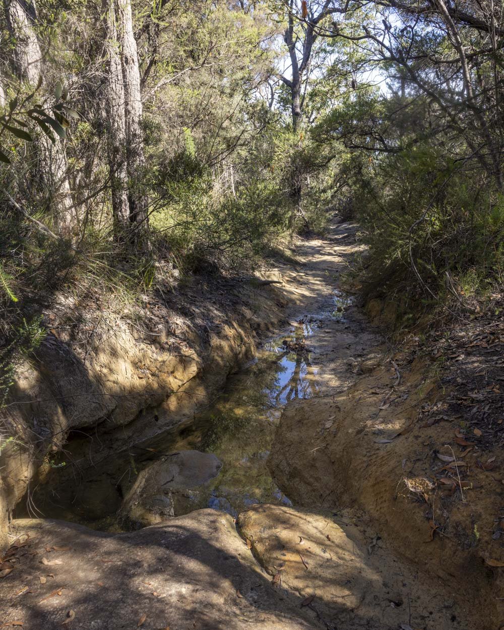
There’s a fairly lengthy stretch of heavily eroded track which gets very waterlogged after rain - and you need to walk this track after rain for the chance to see the waterfall in flow.
The climb to the viewpoint at the end of the trail is on a rougher bush track, but it’s not slippery and though there is a little debris, it’s quite easy.
Starting the trail
From the parking area (see full details below) the walk heads around the locked gate and onto the Tunnel Fire Trail.
The fire trail is very well maintained and it’s either a gentle ascent or flat up to a second gate at the 1.1km mark.

Head around the gate and continue for another 700m to a junction where you keep straight and Rocky Ponds is signposted.

You’ll come to a third gate after another 600m and the track now heads uphill and gets a bit bushier.
There’s another signpost for Rocky Ponds 450m later, at the 2.85km mark. You’ll continue straight, now heading onto the Great North Walk, though it’s still a fire trail unfortunately.


Roughly 500m later you turn right, again following signs for Rocky Ponds.
Reaching the narrow bush track and Rocky Ponds
There are no further turnings to make for the next 3.7km and the fire trail will continue undulating.
When you reach the section which crosses a rock platform at the 4.7km mark you can look out for the well preserved Indigneous engraving.


There’s nothing else to note until just over 7km into the fire trail when you reach a point where the track curves left. Instead of keeping on the fire trail you need to look for the narrow path heading into the bush, directly ahead of you.

This is the start of the 700m eroded section of track. It’s relatively dry at first, but gets progressively wetter and more eroded as you continue.
I did slip into the water at one point when trying to avoid it using the bank, but that was carelessness on my part!

After approximately 700m on this track you will reach a set of trickling cascades on Tank Creek.
Unless it’s in flood, you can very easily walk down these cascades for a few metres before bearing left to reach the main cascades known as Rocky Ponds.

Beyond Rocky Ponds to Jeannie’s Pool
If the walk ended at Rocky Ponds you’d be forgiven for sending us a disgruntled email wondering why on earth we’ve included it on our website.
The small cascades, while nice enough, are certainly nothing to write home about! However, it gets better from here.

From the rock platform by the larger cascades, walk to the end of the rock shelf and look for the discreet track heading into the bush on the right. Follow the worn dirt track which is a little overgrown, but not too bad overall.
After a couple of hundred metres you’ll see a path leading left, it’s actually the second path on the left you’ll see, but the first is less easy to spot and leads to a view over the waterfall from above.

The track to the bottom of the falls is a bit rocky at first as you briefly descend before it then reverts back to a dirt track, which is flatter to the base of the waterfall, just 60m from the junction (310m from Rocky Ponds cascades).

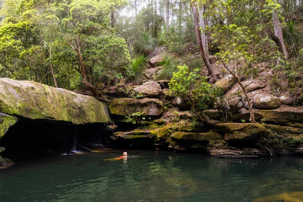
Swimming at Jeannie’s Pool
Coordinates: -33.5274405, 151.2527043
Even after some good rainfall the waterfall at Jeannie’s Pool is dainty rather than dramatic, but the setting is just beautiful.
The surrounding sandstone rock walls are dripping in ferns and dense foliage and tall gum trees complete the scene.

The water is emerald even when the water is in shadow, which I think, due to the gum trees, is most of the time.
It’s really serene and the kind of place you can come on a hot weekend - as we did - and see no one else at all. Granted, you’ve worked hard for it, but if you like a long walk then I guess that’s no biggie!

The water was a lot deeper than it looked from outside the pool, I thought it would be one for sitting in only, but it was well above my head throughout much of the pool.
Accessing the water is quite easy, but there are a few rocks in the early part of the pool to watch out for. Once at swimmable depth I didn’t encounter any rocks or debris in the water so it was very relaxing.

Continuing to the second waterfall
From Jeannie’s Pool head briefly back along the dirt path, but instead of ascending to retrace your steps, continue downstream.
You’ll pass another pool and some cascades which could have been another nice swim spot, but it was laden with debris on our visit.


Just 150m beyond this pool and 240m beyond Jeannie’s Pool, you’ll come to a large rock platform and the point at which Tank Creek flows over a steep cliff.
The view from the top is gorgeous, overlooking the Hawkesbury River and Ku-ring-gai National Park in the distance.

This is a nice spot to sit and relax, with plenty of room to spread out on the rock platform and enjoy the views. Though the best view of the waterfall itself is from a little further along the track.

Reaching The Icicles
Coordinates: -33.5288112, 151.2493652
The most spectacular view of the whole trail can be found 400m from the rock platform and is known as The Icicles.
To find the trail you need to walk part way down the rock platform towards the top of the waterfall and look for the track leading into the bush on the right, keeping the creek on your left.

It’s narrow but quite obvious. After 50m heading uphill along the track you’ll see a large rocky outcrop on your left.
There’s a huge drop to be wary of, but the rock is grippy when dry and you don’t need to go near the edge for a great view back over the waterfall and out towards the bay.

Once back on the bush track, continue for another 100m at which point you’ll cross a tiny creek (basically one step across).
Around 50m later the path becomes more indistinct, but you want to bear right, heading uphill on a now rougher track.


It’s uneven underfoot and a bit steeper, but not too difficult. You’ll reach a series of large rocks on the cliff edge 200m later and this is The Icicles.

You need to cross to the rocks on the edge of the cliff or the bush obscures your view. It’s another sheer drop to the bay below, but again, there is plenty of room to sit back from the edge and take in one of the best vistas on the Central Coast.
The Icicles
The view from The Icicles is a stunner. The bay with its forested cliffs and distant hills is incredibly picturesque and it’s also the best vantage point of Dangar Island we’ve seen yet. It was fun to sit and watch the ferry and sailboats pull in.

You can also see the Mooney Mooney Bridge to the right. Spion Kop is still my favourite viewpoint in the area, but The Icicles is now in second place.
We were hiking on a weekend, so we also got to enjoy watching everyone sitting in the water and gorging on oysters as part of the oyster farm tour far below us.


We wondered what people would think if we shouted down and they could just make out two little figures on what must look like an impenetrable rocky outcrop from below.

When you can tear yourself away from the view and muster up the energy to tackle the long fire trail back, you simply retrace your steps to the car park.
Keep them wild
Please remember to take all rubbish with you and keep these places wild and pristine - as with anywhere in the outdoors. It’s important to leave them exactly as you found them so they will remain beautiful for generations to come.
Litter tends to breed litter, so if you do spot any and are able to pick it up and dispose of it outside the national park, it will go a long way to keeping the area clean.
Parking for the Rocky Ponds Track
The Rocky Ponds Track begins at the car park beside the Tunnel Fire Trail in Woy Woy, you can see it here on Google maps. It’s worth nothing that this is also the trailhead for the ever popular Woy Woy Waterfall, so parking on hot weekends can be an issue.
There are no facilities at the trailhead or anywhere along the route.
This post may contain affiliate links, meaning at no additional cost to you, that we will earn a small commission if you click through and decide to make a purchase. This helps towards the costs of running our website. Thanks for your support.