There are a lot of incredible views in Sydney, but few walks string together as many stunners as the Balls Head to Lavender Bay walk. It’s a trail we do most weeks and it always reminds us how lucky we are to live in such a beautiful city.
However, this walk isn’t just about the views. Along the way you’ll experience bushland, a secret garden which makes you feel like you’re a million miles away from the city and even an ancient aboriginal carving.
The trail starts in an area that has been radically transformed from a coal and oil industrial site to a regenerated inner city garden space, blending some of Sydney’s history with the modern urban development. It then goes onto the world famous Lavender Bay before finishing under the iconic Harbour Bridge - a fitting end to a beautiful walk.
So here’s everything you need to know about the Balls Head to Lavender Bay Walk - one of our favourite harbour walks in Sydney.
The Balls Head to Lavender Bay Walk
The stats
Distance: 7.1km (you can shorten it if preferred)
Elevation gained: 155m
Difficulty: Easy
Type of trail: One way
Start of trail: Waverton Train Station
End of trail: Milsons Point Ferry Wharf
Whilst this walk isn’t hard, it is quite lengthy and has a couple of points where you’ll walk up several flights of stairs. It’s enough to get your heartbeat going, but the majority of the trail is flat. We’ve classed it as easy, but anyone looking for a leisurely stroll should probably consider doing this trail in reverse, starting at Milson’s Point and finishing at McMahons Point - the halfway point of this walk.

The start of the trail - Waverton Station
The trail starts at Waverton Train Station on the North Shore line (it’s the stop after North Sydney). Exiting the train station, turn left and head down the hill. If you walk on the right hand side of the road, the pavement almost immediately gives way to dirt track and though you are still walking along the road you do get glimpses of the water and it’s very leafy. Soon you’ll come to a cross roads, keep going straight and you’ll see that the bushland begins to form around you.
Follow the road to the right at the fork and continue onto the Coal Loader.
The Coal Loader
You’ll soon reach the “Aboriginal Bush Foods Garden”, a place that was once owned by the Cammeraygal Aboriginal people. The garden has edible and native plants and there’s an information board to explain what’s there.
After the bush food garden, you’ll appear at an ancient aboriginal rock carving. It’s well sign posted, but not so easy to see as it is fairly weathered. If you look closely you’ll see the outline of a whale that’s about seven metres long. It’s believed that there are a lot more engravings underneath the current buildings, and some other figures have already been rediscovered.

White line added to help you see the outline of the whale!
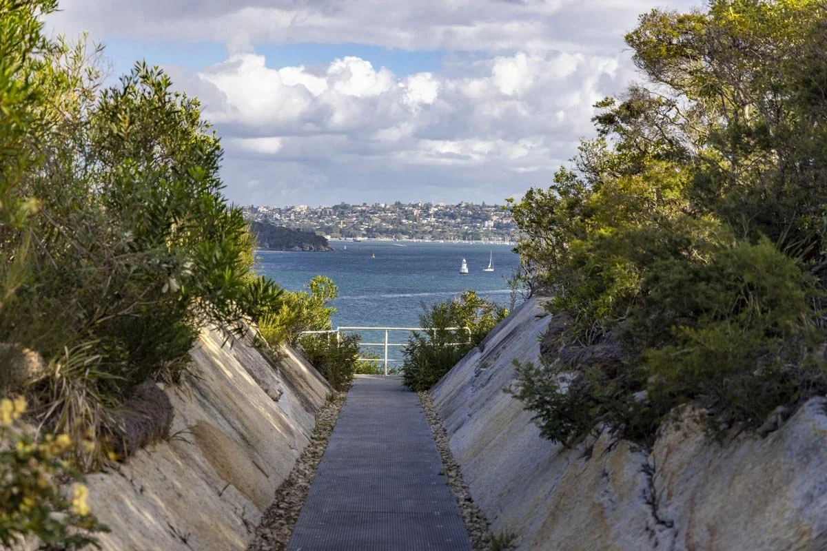
The carving is next to the Coal Loader which was an industrial area between the 1920s and 1992, it’s where coal was loaded onto ships to be transported. Since 1992 it has been transformed into a big public space with lots of plants and a platform overlooking the harbour.
Another great walk: The Bondi to Coogee Walk - one of Sydney’s best
Balls Head Reserve
Continue down Balls Head Drive towards Balls Head Reserve, where virtually every building disappears and is replaced with classic Aussie bushland. There are a few little surprises, the first being the numerous Brush Turkeys who call this place home. We regularly walk here and have seen at least one every time but usually there are loads!
As you follow the road left you’ll get some glimpses out to Berry’s Bay, when the road hairpins, carry on straight to the dirt path. This will take you into the bushland and around the shoreline, continue straight, don’t take any of the right hand turns.
After around five minutes the path opens up at a picnic area with views of the Harbour Bridge. Unfortunately it’s obscured by the Blues Point Tower (one of Sydney’s ugliest buildings), but you will get better views further along the trail! Head across the picnic area to the path that runs alongside the water. This trail leads downhill to a rocky outcrop with a great view of Goat Island and the new Crown Tower at Barangaroo. It’s a favourite spot with fishermen, but we like it for the view.
Heading back on the main path, the trail heads uphill before reaching the main picnic area with benches. Keep left - don’t head back onto the road - and follow the path into the bush. You’ll come to another viewpoint which looks straight out to the Sydney Tower and it’s a great view of the skyline.
After the lookout you’ll continue hugging the shoreline and there will be some rocky outcrops on your right which are a favourite spot for kids practising their rock climbing skills - it’s not that high, but it’s a fun scramble!
Eventually the path heads back out to the road. Continue along the road until you see wooden stairs to the right by a sign for Carradah Park. Head down the staircase and cross over the road and continue on the concrete path.
Carradah Park
Carradah Park is a former BP site, where fuel was stored before being transported onto the ships. Just like the Coal Loader, it was redeveloped into a public park and named after an Cammeraygal man Carradah who befriended Lieutenant Ball - the man who Balls Head Reserve was named after.
The park has lots of stone remnants of the fuel storage tanks, but there’s also a lot of native plants and bush so it still feels close to nature.
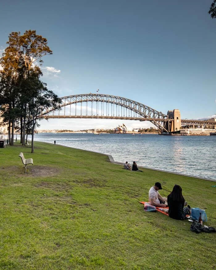
Follow the path until you come to a staircase on your left. This leads to one of our favourite viewpoints in the whole of Sydney - Larkin Street Lookout. From here, you’ll look down on Sydney Harbour, the Harbour Bridge and the Opera House, and it is particularly beautiful at sunset or sunrise.

From here, follow the metal walkway which continues to give you more great views until you reach a staircase heading downhill to your right. Walk down the staircase, turn left and you’ll quickly come to another set of stairs on your right. They lead to Waverton Park, a big patch of grass right by the harbour which is a favourite with local dog walkers.
Onto Sawmillers Reserve
After Waverton Park, there’s a short amount of residential walking you’ll have to do. It should only take 10 minutes to get back onto the harbour and the greenery though!
Cross Waverton park until you get to John Street that heads steeply uphill. Go under the bridge and take a right at Dumbarton Street. Follow this until you reach Munro Street and take a right. This path will lead all the way back downhill until you reach the water again. At the water you’ll see a path that leads to a boardwalk.

From here you’ll reach Sawmillers Reserve - the site of an old sawmill. There’s still remnants of the sawmill here as well as a beached and rusty ship along the shore! It’s a lovely place for a picnic as the park is right on the water and overlooks Barangaroo and Goat Island. It’s an inner city oasis, filled with bird song and the lapping of the water against the rocks.
Take the dirt path uphill and along West Crescent Street to Blues Point Road. The view at this turning used to be world class, but recently they’ve erected a metal shed that obscures the view whilst they build the train line. You will still get the million dollar view though, just not yet!

Sawmillers Reserve
Blues Point Reserve & McMahons Point
Here’s an insider tip - at Blues Point Tower take the path that heads right (it’s between the car park for the tower and another residential building and is signposted as access to foreshore via steps). This will lead to a staircase that drops you down to the water and a path that very few people take.
The path winds round Blues Point Tower with views of the harbour before opening up at the view of the Harbour Bridge. Soon you’ll arrive at Blues Point Reserve - another lawn that is a picture perfect spot for a picnic. It’s also a great place to watch sunrise as you look straight onto both the Opera House and Harbour Bridge in the direction of the sun rising above the horizon.

After crossing Blues Point Reserve, take a right at Henry Lawson Avenue and onto McMahons Point. The view here is possibly our favourite in the whole of Sydney, a place so beautiful that many people choose to get married here - two of our friends did!
The views across Lavender Bay to Luna Park and the Harbour Bridge are simply stunning.
By now you will have walked 5.3km. The remainder of the walk is 1.8km, but you can always hop on a ferry from McMahons Point if you’ve had enough.
Onto Lavender Bay
If you’re still hiking on, be prepared for stairs. Lots of stairs. This section of the walk requires a bit more residential walking, but it will be worth it.
Take the path to the left of Sails restaurant (another place with an epic view) and head up the big staircase. At the top of the stairs take a right along East Crescent Street. There’s some pretty fancy houses along here which always gets us talking about what it would be like to live there!
Keep walking straight and take the right fork down Bay View Street. Stay on this street until you see a sign for “Walkway to Milsons Point via Lavender Point boardwalk”. The stairs head down to Lavender Bay and you’re back at the water again.
Be prepared for yet more stunning views as you edge closer to the Harbour Bridge. We love the little boats that are dotted around the bay and the picturesque boardwalk adds to the atmosphere of Lavender Bay.

Wendy Whiteley’s Secret Garden
If you thought you were on the homestretch, think again! It’s a 300 metre detour, but we highly recommend heading to Wendy Whiteley’s Secret Garden - another oasis in the city! Take the underpass on your left and head up the stairs until you see the turning into the garden.

This beautiful garden is an absolute delight and it really does feel like entering another world. There’s a huge amount of colourful flowers and tropical plants as well as a ginormous Fig Tree and an overall jungly vibe. There are picnic benches with parasols which make it another of the best picnic spots in Sydney. You’ll occasionally get a glimpse of the Harbour Bridge through the branches, just to remind you that you’re still in the middle of one of Australia’s biggest cities!

The Lavender Bay Boardwalk
Retrace your steps to Lavender Bay and walk along the path towards the Harbour Bridge and Luna Park. This picturesque boardwalk is pretty popular, but few people spot all the tiny statues hidden in the bushes along the way.
These make up the Comic Walk which ends at Luna Park, and makes a nice addition if you’re walking with kids.
The path to Luna Park
The sculptures on the Comic Walk
Eventually the path reaches Luna Park - a Sydney institution. Many visitors are surprised that an old fashioned theme park sits in one of the most prime real estate locations in the world, but Luna Park has been operating here since 1935 and was modelled on the Luna Park in Coney Island, New York. It has heritage status and is one of only two amusement parks in the world that is protected through government legislation.

The old wharf at Lavender Bay
The main eye catching feature is the big, slightly scary face that is the entry to the park. It is the eighth iteration and is based on Old King Cole - a British Nursery rhyme.
If you still have energy, you can take a dip at the North Sydney Olympic Pool, an outdoor pool with a stunning views of the Harbour Bridge while you swim!

The wharf at Milson’s Point is the end of the trail and you can either hop on a ferry, walk up the hill to get a train, or walk across to Kirribilli for one our favourite sunset spots in Sydney - Jeffrey Street Wharf. It’s an incredible spot and highly recommended if you’re here at the right time.
If you’re really keen, you could extend the walk even further by walking over the Harbour Bridge to The Rocks, we’ve got all the details on that walk in this post.
Transport for the walk
The trail starts at Waverton Train Station which is on the North Shore line.
There are two places you can finish the trail:
1) McMahons Point and either get a ferry to Circular Quay or Darling Harbour, or a bus up to North Sydney Train station, or
2) Milsons Point and either get a ferry to Circular Quay or Darling Harbour, or the train.
Packing suggestions for the walk
Having the right gear can make a huge difference. Here’s what we pack and have relied upon for years:
Sunscreen: Cancer Council Active. With a high SPF, but not the greasy feel of other sunscreens. Makes a big difference when you’re working up a sweat on a sunny day! Check it out on Amazon
Good Rain Jacket: North Face This is an essential item we always pack in our bag! This jacket from North Face is designed to keep you dry but also comfortably warm (many rain jackets will make you feel like you’re in a sauna). Check it out on Amazon
Day Pack: Osprey Talon 22 (we’ve owned this for years). Check on Amazon or direct with Osprey
Hiking Boots: Merrell Moab (for men and women). We’ve both used these for over three years and they just keep going. Check them out on Amazon
Trekking poles: We’ve used Black Diamond for years as they are light, solid and durable. Check them out on Amazon.
Reusable water bottle: To avoid single-use plastic. Check them out on Amazon
This post may contain affiliate links, meaning at no additional cost to you, that we will earn a small commission if you click through and decide to make a purchase. This helps towards the costs of running our website. Thanks for your support.
Like it? Pin it!

Follow us on social media
What’s your favourite walk in Sydney? Have you done the Balls Head to Lavender Bay Walk? Let us know in the comments below!