

Alligator Gorge is one of our favourite places to walk in Australia. With dramatic scenery - including an incredible slot canyon - as well as great views and plenty of wildlife, it completely exceeded our already high expectations.
There are a couple of ways you can explore the gorge depending on what length walk you want to do. We’ll tell you about the short hike to the most spectacular part of the gorge, as well as the full Ring Route track.
Here’s everything you need to know about Alligator Gorge.

Alligator Gorge
Which trail to choose
We chose to walk the full Ring Route, which is 10.2 km long (1.3 km longer than the sign says!). This also encompasses the shorter walk you can do, which is through the most spectacular part of the gorge.
The short route (where you only visit the Narrows) is about 2.5 km return and will take you down a series of staircases before you come to a signpost at the bottom. Take the left turn and you’ll be at the Narrows.

This section of the gorge is utterly magical and completely blew us away. We were absolutely not expecting to feel like we’d been transported right back to the Narrows in Zion, Utah, but we were! We’ll take you through exactly what the section is like at the end of the post, because it is how the longer Ring Route finishes.
If you only want to see the best bit of the walk definitely take this short option.

The Ring Route has some lovely scenery, but it also has a 4km long section which is just on fire trail. It’s also rougher and a little more challenging than The Narrows. We’d recommend it if you’re keen to do a longer hike, but otherwise we’d suggest the short route.
If you do want to do the full Ring Route make sure you walk anti-clockwise so that you finish on the most special part of the walk. Trust us, it’s a fabulous way to end the trail.
A note on water in the gorge
Before we go into the full Ring Route track we thought we’d better mention that we had quite exceptional circumstances on this walk. There had been huge amounts of rain for the previous two weeks before our visit and the gorge was in full flow.
If you’re happy to get wet and you’re lucky enough to be able to coincide your visit with recent heavy rain, then it’s definitely the best way to experience the gorge (don’t walk during rain though as flash flooding can occur).
If you’d prefer to stay dry and have an easier walk you’ll want to visit after a dry spell when the water levels are very low and in places non existent.
If you are going to do the hike when it’s flowing we’d recommend wearing river shoes, we didn’t even know we’d be walking through water and wore out hiking boots and trousers which was ok but not ideal. Shorts and river shoes would definitely be preferable!

The Alligator Gorge Ring Route
The stats
Distance: 10.2 km loop
Elevation: 380m
Difficulty: Moderate when dry, moderate-hard when very wet
The Ring Route of the Alligator Gorge Trail is a moderate to moderate/hard trail depending on the amount of rain! The raised water levels when we hiked made it slow going (we took 3.5 hours). However, the water levels made it all the more fun :)
Starting the Alligator Gorge Trail
You’ll begin the hike by heading down several staircases until you reach the gorge. Head right following the sign for Alligator Gorge, saving The Narrows for later.
You’ll begin by heading along the creek through the forest and it’s very pretty and shady. It’s also flat and on a well maintained path, enjoy it while it lasts!


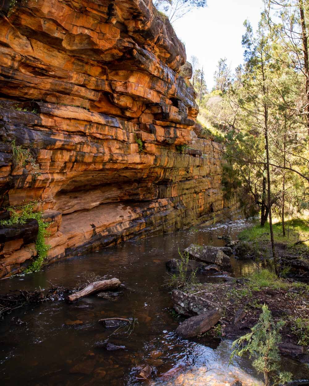
After 900m you’ll cross over the creek before coming to The Terraces. I’d recommend that if the creek is flowing pretty high on this first crossing then rather than do what we did and use rocks and logs to cross, just walk through the water instead.

We wasted loads of energy by trying to cross on rocks for the first couple of kilometres before finally realising that we’d be better off just going through the water, hiking boots and all.
It was so much more fun once we’d made this decision and soggy boots aren’t too bad once you get used to them!

There will be a few spots where the water might be running too fast, but generally it was ok to slosh through in most places.
Onto The Terraces
The Terraces are a set of pretty cascades (which could be dry if there hasn’t been rain) and are easy to walk up as the rock shelving is nice and grippy.
You’ll see a small waterfall to your left a few hundred metres later, you can get up close if you don’t mind a little bush bash to get there.


The terrain gets a fair bit rougher after The Terraces. Even if it’s bone dry you’ll still be walking on broken rock and up and over logs.
There are flat sections on a normal path too, but there’s a decent amount of clambering throughout.

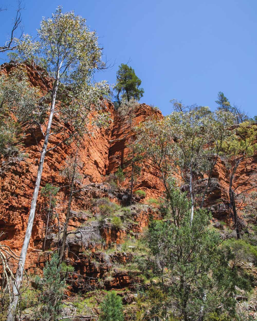
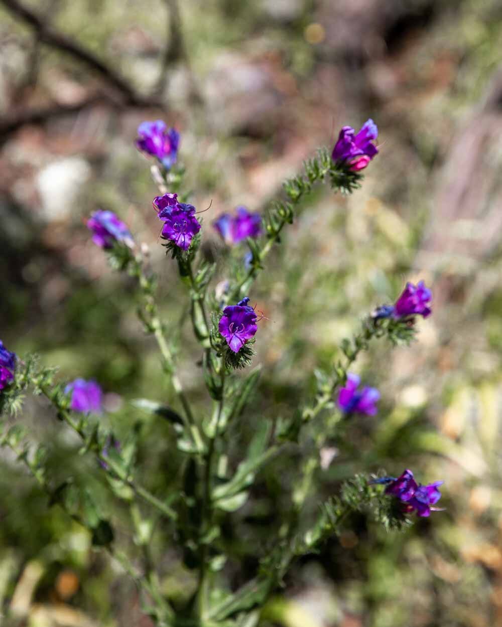
The scenery is gorgeous though, with deep red gorge walls and lots of pine trees. There were lovely swathes of purple wildflowers and little blue butterflies too.

If there’s water in the gorge there will be a couple of log crossings to do and some sections where you’ll walk along narrow paths beside the cliff walls (although at this point we would probably have been better going through the water, as mentioned).

Everyone turns back
After 2km everyone on the walk turned back, one by one, and we wondered if we might have to do the same! The rock hopping was pretty tiring and sticking to the edges of the cliff walls meant some fairly close encounters with a huge number of spiders (small ones, but being a Brit they still scare me!).
Most people said they were turning because they didn’t like the track and because of poor signage. Whilst it’s true there is very little signage, you really can’t go wrong because you’re just following the gorge. The exact route is up to you and we just tried to find the one of least resistance.

At any point in the walk you need to make a turning, it is signposted, so don’t worry about directions. After 2.5km slow kilometres we decided to take the plunge into the water. It was that or turn back as we were moving so slowly!
Minutes into the water and we were both laughing that we didn’t just do it from the first moment. It was miles easier and a lot more fun.
We still used rocks and logs anywhere where it looked like it was flowing a little fast, but for the most part using the waterway was by far our best decision of the day! As soon as we did, I knew we wouldn’t have to turn back.

Whether it’s wet or dry, you’ll be walking uphill on roughish terrain until you’ve walked for 3.7km. At this point you leave the the gorge and head on to a normal bush track.
The bush track
The bush track is a really well maintained path with lots of steps at first before levelling out. There are lots of birds and lizards (we found the biggest Goanna we have ever seen!) and as you climb higher you start to get some wonderful views over a sea of trees.
It’s also a really nice break after the rocky nature of the gorge. I found it pretty relaxing, but it is very exposed so you will feel the full heat of the sun.


After a kilometre you’ll leave the narrow bush track and reach a fire trail. Your route is signposted as Alligator Gorge car park.
It says 6km away, and our watch said we’d already walked nearly 5 km at this point, but it might be out because you have to crisscross the gorge so often that you rack up lots more steps.

You’ll be walking on the wide stony fire trail for the next 4km. We’re not great lovers of fire trail but this one is prettier than most with some lovely bush on either side and at points fantastic views all the way out to the sea!
We also saw a huge kangaroo in the middle of the day, so I’m sure you’d see a lot more if you ‘re walking earlier or later in the day.

The fire trail is entirely downhill, so you can make quick work of it, yet another reason to walk the track anti-clockwise as I think it would feel like a real slog if you have to walk up it!
You’ll pass a couple of campsites and cross a small river, but other than that there isn’t much to note until you reach Blue Gum Flat (another campsite, and picnic spot).

At this point you’re moments away from turning onto The Narrows track.
The awe-inspiring Narrows
The beginning of The Narrows is a regular bush track. A narrow path which heads downhill and is nicely shaded. After 350m you’ll reach a rocky section of creek which you cross over and it’s all very picturesque and relaxing.
After another few hundred metres in the forest you come to a glorious sight. The deep red narrow walls of the gorge with the creek flowing through the middle. It was so pretty we stopped on the rocks to sit and enjoy it, having no idea that the best was yet to come.

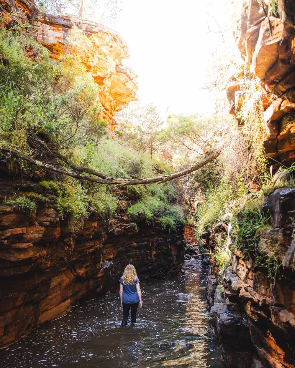
As you make your way through the water (or possibly puddles if it’s dry, either way it will be stunning!) you’ll suddenly come to a narrow slot canyon. It took us right back to Utah and we couldn’t believe that we had no idea that this place existed in South Australia!
It is utterly beautiful and it instantly shot this hike up to being one of our favourites in Australia.

The water looked deep but it was rarely above knee height and unlike the Narrows in America it was easy to walk through.
The flow of the water doesn’t knock you back and the rocks underfoot aren’t generally slippery.
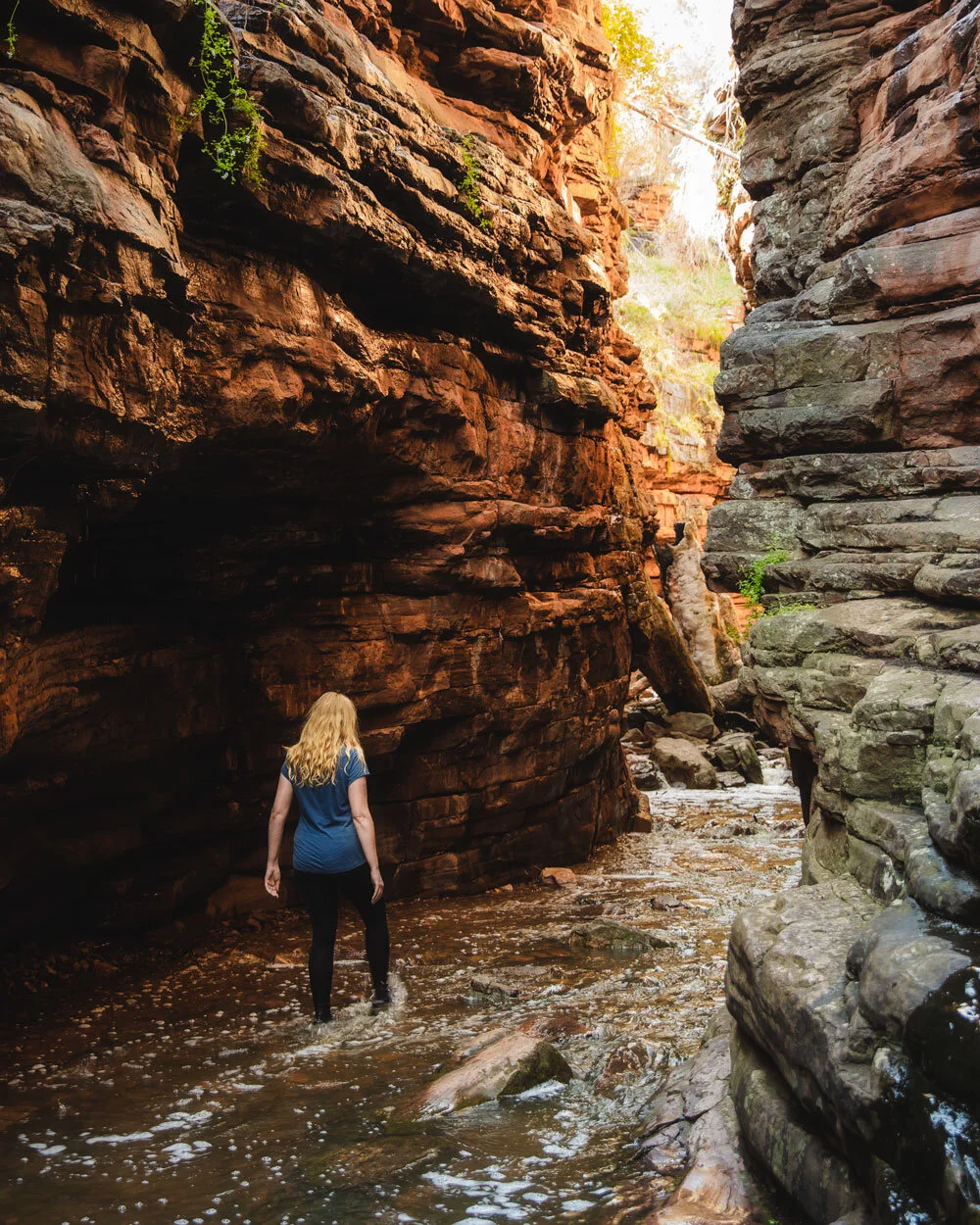

You have roughly 150m of very narrow canyon before it opens up again. You’ll still be walking between the towering red walls and they are a magical sight for the next 450m before you reach the staircase back up to the car park.

The whole slot canyon is lovely and shady and water was cool and refreshing rather than freezing. It is by far the highlight of the trail and it would be worth the drive out to the gorge just to see this short section.


If you are walking just The Narrows you’ll walk through the gorge in the opposite direction, which means you’ll reach the most fun narrow slot canyon section at the end of the walk, which makes for a great finish.
Whichever route you choose it will be an incredible walk.

If you’re so inclined there are also a couple of lookouts you can check out on short trails from the car park. We did the Gorge Lookout which was 250m each way. It’s nice enough but once you’ve been inside the gorge it really can’t compare.
Essential information about Alligator Gorge
Getting to Alligator Gorge
Alligator Gorge is a 20 minute drive from Wilmington, and a lot of that is down a rough dirt road. You don’t need a 4WD, but the road has several gullies, bumps and steep sections.
Wilmington is on the edge of the Flinders Ranges and is a 3 hour 15 minute drive from Adelaide.
Mount Remarkable National Park entry fee
To park at Alligator Gorge you need to pay the national park vehicle entry fee. It’s currently $12.50 per day. You can’t pay at the gorge itself so it’s best to book online ahead of time in case you don’t have signal when you get there. Click here to buy it before you go.
If you are planning to visit several national parks you can also pay $50 for an all parks pass for two months which is what we did. If you live in South Australia you are probably better off buying the annual pass which costs $112.
Like it? Pin it!

Follow us on Social Media
What’s your favourite hike in the Flinders? Let us know in the comments below!


