The Convict Trail is a bushwalk with a difference. It takes you along the Old Great North Road, an amazing feat of engineering that was built by convicts in the 1830’s to link Sydney with the Hunter Region.
What really makes this walk special is the information panels along the way which bring the history to life. There is a mixture of factual information and engaging stories about the lives of individual convicts and you can get even more out of the trail by downloading the app to use as an audio guide. It feels less like a bushwalk and more like walking through an open air museum.
Many people come here just to walk up to the top of the Convict Trail and back down to Wisemans Ferry again. However, to get the most out of this trail (and understand more of the history), we recommend making a big loop that includes Finchs Line - the original road which was in use before the Great North Road. This circuit gives you a better grasp of the Great North Road’s history and is more scenic.
Here’s what to expect on this very unique walk.

Great North Road Convict Trail
There are two ways of doing this trail; either walking up the Convict Trail and back, or making a loop by continuing onto the Finchs Line Trail. We’ll take you through both options in this post.
The Return Walk (The Convict Trail)
Distance: 3.9km
Elevation gained: 145m
Difficulty: Moderate
Essentially the first 2km of the walk is the old convict built road (also known as Devines Hill) which has many information panels along the way. It is a steep walk but there is so much to take in along the way, that you are constantly taking breaks so it doesn’t feel difficult.
This walk is just under 4km in total. All uphill on the way and downhill on the way back. It should take about 1.5 hours (which allows plenty of time to read all the information panels), but be warned: this trail has next to no shade, so it will be incredibly hot on a summer’s day!
The Circuit (Convict Trail + Finchs Line)
Distance: 10.3km
Elecation gained: 252m
Difficulty: Moderate
If you’re a keen walker and you want to explore more of the area we’d recommend the 10.3km loop track, which takes in the whole of the old convict road, as well as the original road that existed before the Great North Road.
The upside to this version is that the scenery along the original road is more beautiful than the convict built road and there are other historical sites to see. The downside is that you need to walk for 2.5km along the main road to connect back with where you have parked your car. We think it’s worth it though.
We took 2.5 hours to walk this version of the trail.
The Great North Road Convict Trail
The history of the Old Convict Road
The Great North Road Convict Trail is a fascinating piece of Sydney history and a great insight into how tough life was as a convict in Australia. After struggling to find good farmland, the colony discovered the lush land of the Hunter Valley.
The dilemma was how to connect it to Sydney by land. If you’ve driven between Sydney and Newcastle, you’ll probably have seen how the modern motorway has been blasted through the mountains, and is still a pretty incredible piece of engineering.

The Great North Road was a project in the 1830s to cut across the steep and rough land between the Hawkesbury River and the Hunter. It was no easy endeavour, and the first attempt on the Finchs Line (a part of the circuit trail) was abandoned after Governor Darling disapproved of it for being too narrow and precarious to get up in a carriage.
Walking along some of the switchbacks on the Finchs Trail you can understand his decision: the path is rough, narrow, steep and it’s hard to believe a horse and carriage could ever have made it up the steeper sections.

Soon after, the construction of a road further north began, and it eventually became what is known as the Great North Road.
Starting on the old convict road
Only 43km of the original 240km Great North Road still remains intact and undeveloped today. We’ve visited other parts which you can drive along and hop out for a few minutes, but this walk is by far the best section for really getting a feel for the road and its history.
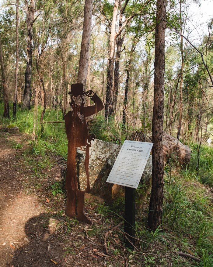
The walk starts just off Settlers Road, and there’s a layby, opposite a gate and a sculpture marking the start of the trail.


At first we thought it had been closed, but soon realised the gate was to block cars driving up the path. You can walk around the fence to start the trail.
A trail unlike any other bushwalk in NSW
From the beginning, the walk is uphill, but it’s unlike any other in NSW. All the way along the Convict Trail there are information panels which have been done really well, with a great balance between history and true stories about the convicts who built the road.
It’s a sobering reminder that the majority of people who were brought to NSW were convicts and forced into slave labour. I can’t imagine how hard it would be to build this road in the oppressive Australian summer, even before thinking about malnutrition and clothing that fell apart and took weeks to replace.
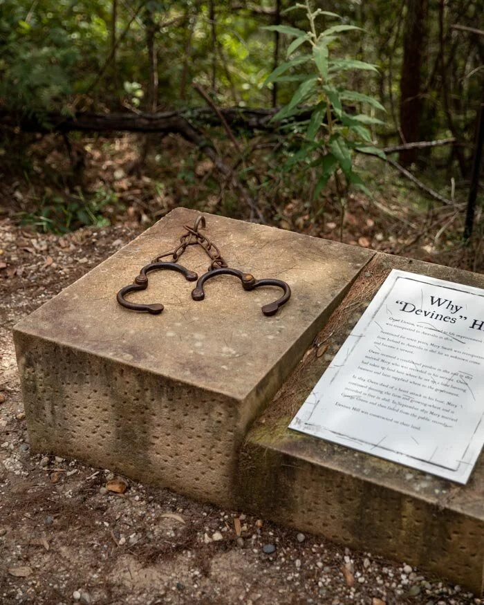
You can see artefacts on display, like the irons some convicts were forced to wear during its construction, and the whip used for lashings as a punishment for rule breaking. In other places you are pointed to drill and pick axe markings that you wouldn’t likely have noticed on your own.
This really made the walk for me, I loved reading the individual stories and it felt like walking through an open air museum. When you realise that many people were sentenced to transportation for petty crimes, it’s all the more shocking.


However, the road is a legacy to their tireless work. To think it was built in the 1830s by hand is staggering and that it has stood the test of time is mind-blowing.
The whole of the old convict trail is on a wide gravel surface which is well graded, and very easy to walk on. It was designed to be suitable for horse and carriage, so whilst it is all uphill, it’s not overly steep.
You’ll get glimpses between the trees out to the Hawkesbury River on your left, but primarily this section is all about the history.

There are places to pause roughly every few hundred metres, so despite the fact it’s relatively steep, you never feel like it’s too much of a struggle. We walked the trail in spring and there were wildflowers running along much of the way, which added to the beauty of the area.


As the path winds its way up the hill there are some lovely views looking back over the curved road, particularly as you near the end of the trail.
After just under 2km you’ll reach the end of the Convict Trail and then you have the option to return the way you came, or complete the longer loop track.

Creating the loop: The Finchs Line Trail
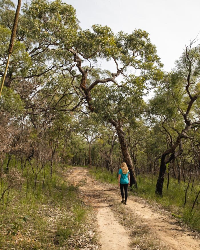
Once you get to the end of the Old Great North Road, you have 400m of wide fire trail to walk before you make a right hand turn on to the Finchs Line Trail, which was the original road, in use before the convict built road.

The road is much, much narrower so it feels like a bush track rather than an actual road.
The Finchs Line is roughly 5.5km long, and gets more beautiful the further along you go. The first section is much greener than the old convict road, with bushland lining both sides of the path, which offers some decent shade.

It is also completely flat, so it’s really relaxing. In fact, almost all the climbing is done on the convict road so the rest of the loop is nice and easy.
There continues to be information panels and historical sites along this part of the walk, but you would get more out of using the app on this section, as there were extra numbered posts that didn’t have any signage but obviously had historical interest.

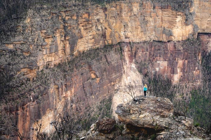
After just under 2km you’ll reach a turn off on the right to a viewpoint. It’s not marked as a lookout, but it’s very obvious and you couldn’t miss it. There are a number of large rocks you can sit on and look over the Hawkesbury River.
A few trees obscure some of the view, but there are more open vistas further along the trail, This one is still worth visiting as it feels secluded from the main track, almost like a hidden lookout. It’s a lovely spot to sit and watch the world go by


Onto the most beautiful part of the walk
After you re-join the main trail from the lookout you have reached the most spectacular part of the trail.
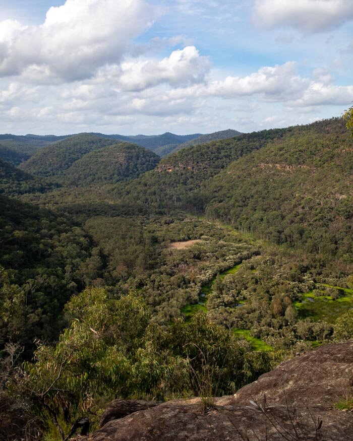
The forest gets more beautiful and the views and craggy overhangs really add to the trail. Roughly 800m on from the lookout you’ll reach a series of big boulders which offer clear, expansive views of the Hawkesbury. A little further on, you also start to get great views over the tree covered hillside to your left too.
The path narrows and becomes like a proper walking trail and it’s incredibly picturesque. There is a very small bit of incline along this part of the track, but no steep climbing.
At the 6.6km mark you’ll begin the descent back down to the road. The first 400m or so are very rocky, but it’s not in any way slippery or difficult, just a bit rougher than the smooth path to this point.

After that, the trail gets better and the descent is quite gradual. It’s also absolutely stunning, by far my favourite stretch of forest. There are Gymea Lillies and other huge tropical plants, as well as hundreds and hundreds of ferns.

You can see why the people who built the original road thought it was superior, not for the road quality, but for the scenery.
After the last 800m of gorgeous forest track you’ll come to the road.

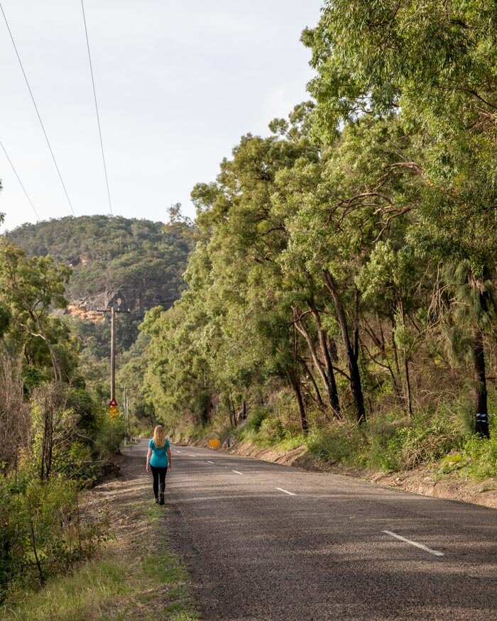
The road back
It’s a shame there is no way of walking beside the river, because 2.5km along a main road is not a great end to the walk. Having said that, even when we walked on a Saturday it was incredibly quiet. It’s also completely flat until the last 400m when there is a very slight incline.

There isn’t a pavement to walk on, but there is always a verge. You get some good views out to the river on your left and it’s nice and bushy to your right, so whilst the road isn’t ideal, it’s also not too bad overall.
I definitely think it’s worth it for the chance to walk the Finchs Line Trail as well as the Old Great North Road.
Packing suggestions for the walk
Having the right gear can make a huge difference. Here’s what we pack and have relied upon for years:
Sunscreen: Cancer Council Active. With a high SPF, but not the greasy feel of other sunscreens. Makes a big difference when you’re working up a sweat on a sunny day! Check it out on Amazon
Good Rain Jacket: North Face This is an essential item we always pack in our bag! This jacket from North Face is designed to keep you dry but also comfortably warm (many rain jackets will make you feel like you’re in a sauna). Check it out on Amazon
Bushman Spray: Good for keeping off the mozzies and any other bugs. Check it out on Amazon.
Day Pack: Osprey Talon 22 (we’ve owned this for years). Check on Amazon or direct with Osprey
Hiking Boots: Merrell Moab (for men and women). We’ve both used these for over three years and they just keep going. Check them out on Amazon
Trekking poles: We’ve used Black Diamond for years as they are light, solid and durable. Check them out on Amazon.
Reusable water bottle: To avoid single-use plastic. Check them out on Amazon
Getting to the Great North Road Convict Trail
Getting to the trail head and the Wisemans Ferry
Wisemans Ferry is 75km from Sydney CBD and takes around 1 hour 15 to drive to. The Wisemans Ferry runs every 10 minutes and is free of charge. The journey takes less than five minutes. The trailhead is 500m to the left of where you depart the ferry.
Whilst you can technically get there by public transport, it takes several hours and requires a train and bus.
Parking at the trailhead
There is very limited parking at the trailhead, room for around seven cars or so. If you get unlucky and there are no spaces, you could park on the other side of the river and come over on the ferry as a foot passenger.
This post may contain affiliate links, meaning at no additional cost to you, that we will earn a small commission if you click through and decide to make a purchase. This helps towards the costs of running our website. Thanks for your support.
Like it? Pin it!

Follow us on Social Media
Have you explored any of the Old Great North Road before? Let us know in the comments below!