The Jerusalem Creek Trail is a gorgeous forest walk located in a lesser visited part of Barrington Tops National Park. The walk takes you along a pristine creek, through stunning rainforest which is dotted with striking blue gums.
You’ll pass a series of cascades before reaching a lookout over Jerusalem Creek Falls. It’s a peaceful track, walked to the sounds of the rushing creek and general buzz of insects and birdlife. There are some ups and downs, but it’s all on a well maintained path.
Here’s what to expect on the Jerusalem Creek Walk.

The Jerusalem Creek Walk
Distance: 4.5km circuit
Elevation gain: 160m
Difficulty: Easy, but not flat
Summary: The Jerusalem Creek Walk is all on a well maintained trail which is predominantly uphill on the way, followed by a leisurely descent. You can walk the trail in one of three different ways: a straightforward return walk, a partial loop which branches off the rainforest track, or up the Jerusalem Creek Track and then back via the road.
Normally we would never willingly opt to walk along a road, but this one is beautiful! Both sides of the road are lined with an incredible number of blue gums making it absolutely stunning - not to mention very easy. This is the way we walked the trail and the route we’re describing below.
It’s worth noting: if you only want to see the waterfall lookout you can park at the top car park (Jerusalem Creek Picnic Area car park) and do a short 460m return walk.

Starting the trail
We begun the walk at the Jerusalem Creek Trail car park (it’s the southern end of the trail) and walked uphill on the way and then had a leisurely descent to finish.
The first 200m are along a flat narrow path through the bush which is dotted with blue gums.


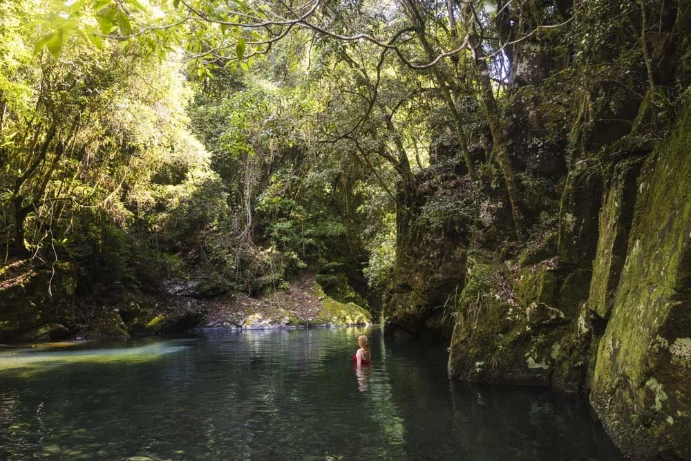
You’ll then have a short (100m) descent before the track flattens and reaches the creek. The creek is crystal clear and you’re now in spectacular subtropical rainforest where the dense canopy keeps the path nice and shady.

At the 400m mark the path begins heading uphill before it undulates. You’ll cross the creek a number of times, but always on well maintained bridges.
At the 800m mark there’s a junction (where there’s a striking knobbly tree) where you need to head right. You then have a steeper uphill section for 100m before the path flattens and then continues to undulate.


Through the rainforest
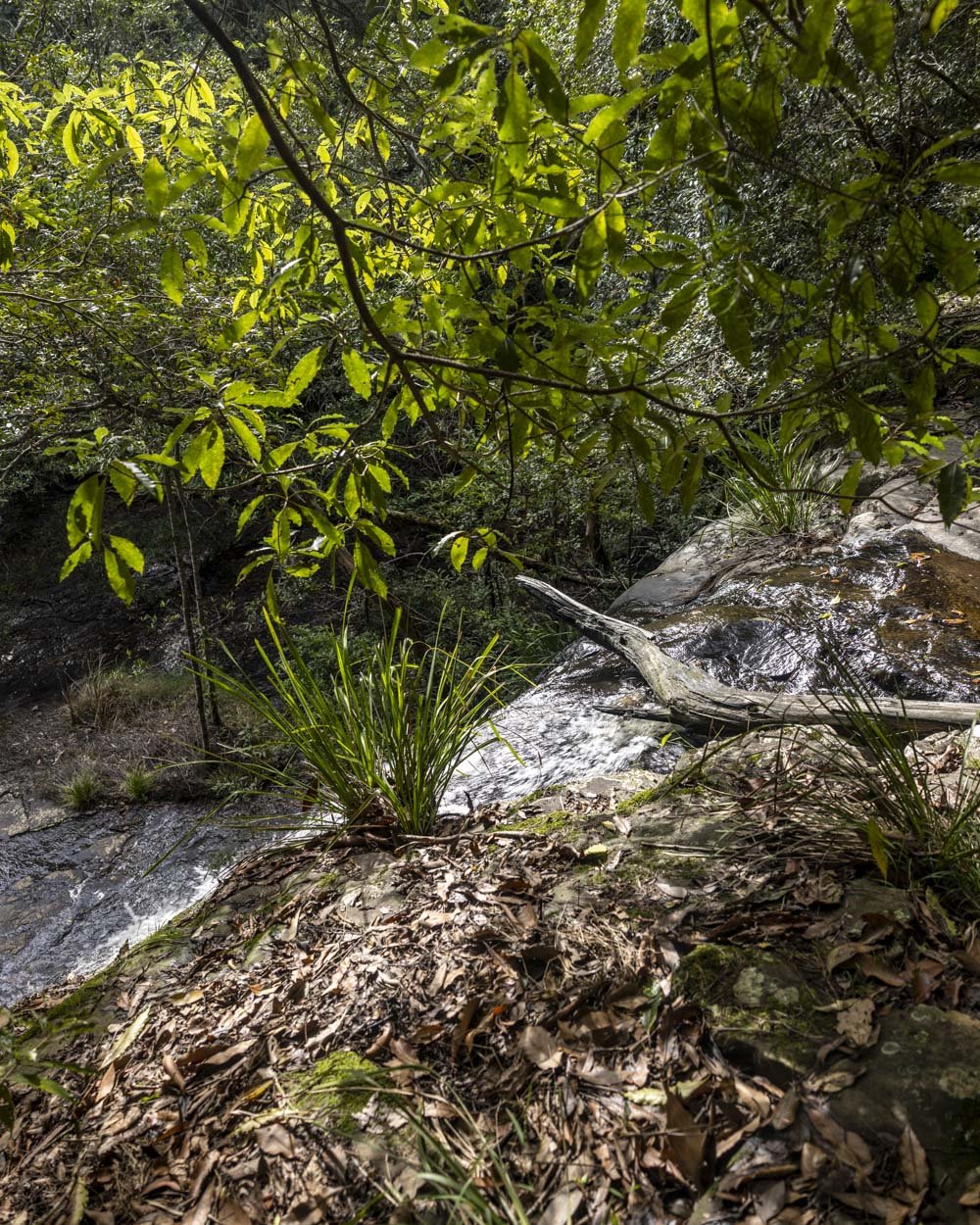
At the 1.25km mark, at a junction, you can take a sharp left to see a set of cascades that are not on the official trail. It’s a 50m detour from the main track and the path is in good condition.


Just before you reach the creek the rocks can get a bit slippery. The rock platform which you view the falls from is also slippery when wet, but on a dry day there are enough patches that are not wet to view the falls comfortably.

The cascades had a lot of water in them on our visit and were definitely worth the short detour. You’ll then head back to the junction and follow the main trail, which is a left turn from the unofficial track.
There’s a 100m steep hill to follow, but the track conditions are good.

Just over 1.6km into the walk you’ll see another narrow path branching off to the left. This is a very short detour to the top of a set of cascades, but in honesty the view isn’t great, so it’s not a must do.
The track then continues heading uphill until just over 2km into the walk you see a signpost for Jerusalem Creek Falls on the left.
Jerusalem Creek Falls and completing the circuit
The small metal viewpoint is just 20m beyond the signpost. It offers a direct view of the falls, but it is at a distance. Despite the fact that we visited after some good rainfall, the falls didn’t have a massive flow.


They were still very pretty, but you’d need to visit directly after heavy rain for the flow to be substantial.
If you want to get a bit closer, you can get to the top of the falls by looking for the path on the left, 130m from the viewing platform.
This leads to the top of the falls 50m later. We didn’t notice a way down to the lower part of the falls, though I have seen photos from a lower angle, so no doubt there is a way down somewhere!

After visiting the top of the falls you head back onto the main trail and follow it uphill through the rainforest for a further 50m when you’ll arrive at the Jerusalem Creek Picnic area.

You could then either head back the same way, or follow the same trail for the majority of the route before taking the short circuit track, which is also through rainforest.
We chose to walk along the road which was 2.2km from where we parked our car. There is a very brief uphill section from the picnic area before it heads gently downhill. We didn’t see any cars at all on the road, so it was really serene.


It’s one of the most beautiful areas for blue gums I’ve ever seen and I actually really loved this part of the walk. As the road is unsealed it fits more seamlessly into the landscape than if it were paved and the quiet nature of it made it feel more like a wide dirt track than a road.

A warning about leeches
Although we loved walking the road, it was not our initial intention. We had planned on doing the rainforest circuit. However, we were walking after some pretty wet weather and the trail was extremely leechy. For this reason - if you are coming after very heavy rain - I would only recommend the section of the trail between the picnic area and the falls viewpoint, unless your tolerance for leeches is high.
We each had to remove 10 leeches from us on the 2.3km walk, though luckily we spotted them and flicked them off, so we didn’t get bitten. I would recommend this track in drier conditions when there should be far fewer leeches, though the trade off is less water in the falls and cascades.
Having said that, we’ve since become better at our leech defences and I think if we had used a good douse of Bushman’s on our boots and socks we would have faired better on this track.
Getting to the Jerusalem Creek trailhead
To follow our route you need to park at the Jerusalem Creek Trail car park at the southern end of the trail. The last 3.8km of the road to the car park is unsealed. If you are parking at the upper car park (Jerusalem Creek Picnic Area), then you have an additional 2.2km of unsealed road.
At time of writing the road was in great condition and suitable for any vehicle in dry weather. Roads like this can deteriorate over time, especially after heavy rain, so if you don’t have a 4WD it’s best to check with the national parks service about current conditions before your visit.
The trailhead is 20km and 25 minutes from Dungog and 82km and 1 hour 15 minutes from Gloucester.
This post may contain affiliate links, meaning at no additional cost to you, that we will earn a small commission if you click through and decide to make a purchase. This helps towards the costs of running our website. Thanks for your support.