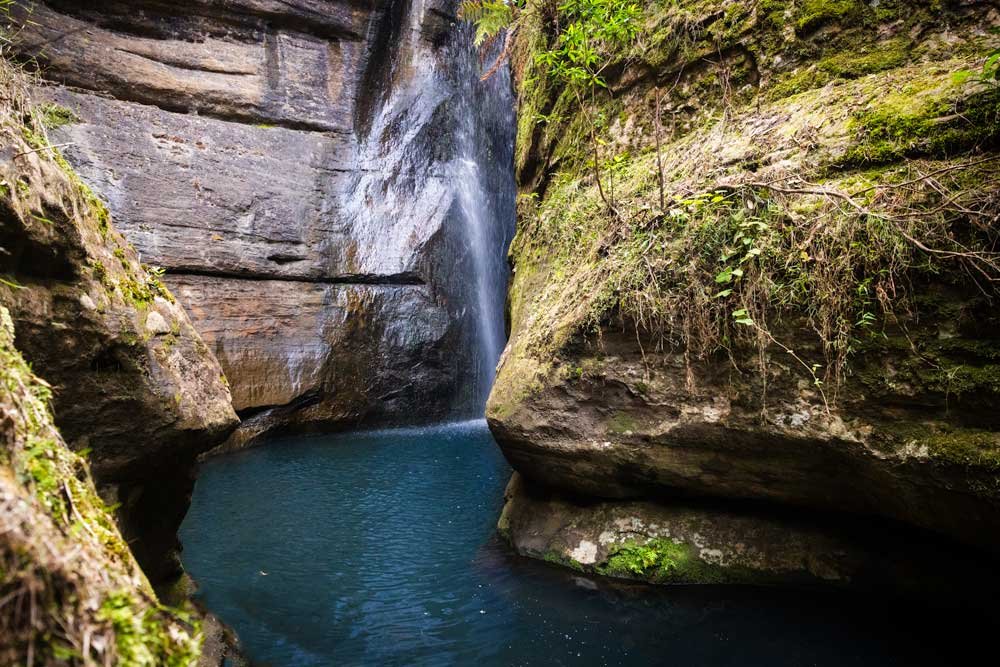
Reaching the swimming hole at the end of the Couridjah Corridor Track requires effort, but your reward is a truly special swim spot that you’re almost guaranteed to get to yourself. The water is as clear as I’ve ever seen in my life and the views are spectacular. It’s one of those places that you have to experience for yourself, there’s just something about the feel of the place that is so enchanting.
There are many spots along Little River that are far easier to reach, but if you’re up for a long walk, then you won’t be disappointed with this one.
Here’s what to expect on the Couridjah Corridor Track via Blue Gum Creek.

The Couridjah Corridor Track
The stats
Distance: 17.6km return
Elevation gain: 260m
Difficulty: Moderate due to length
Summary: The Couridjah Corridor Track is a long walk, but the trail conditions are generally good. In fact the entire walk is on a fire trail.
The vast majority is flat, though there are a few steep ups and downs in the last few kilometres of the track. One or two of the downhill sections had some loose gravel and I found it easier to run down these bits. Other than that (which is really only a tiny section of the walk) the track is long, but easy going.

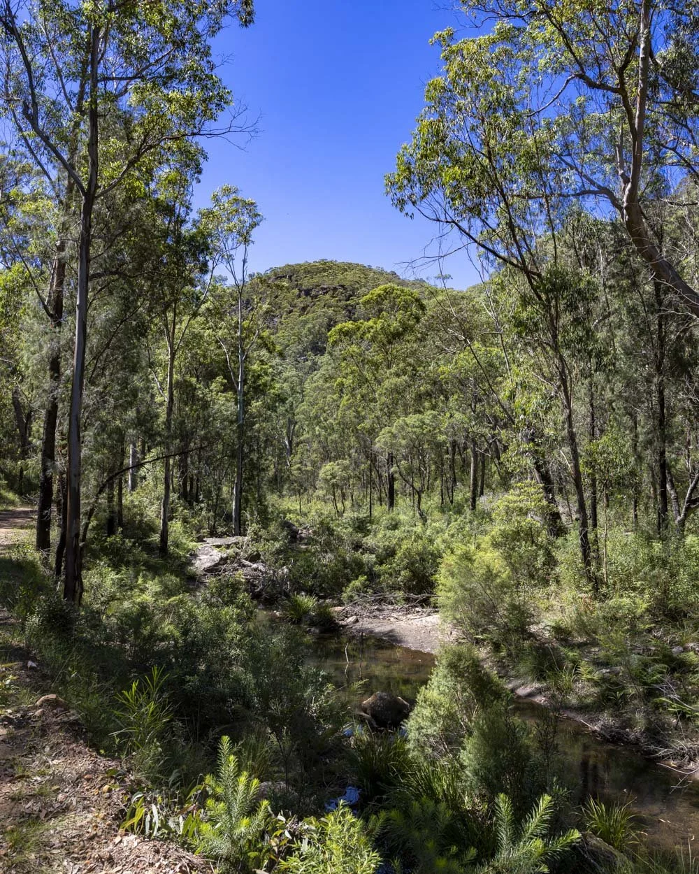
Starting the trail: through the blue gum forest
From the parking area (details below) the walk heads up the fire trail for 150m before passing around the side of a gate. You’ll now begin my favourite part of the entire walk, which takes you through a dense area of blue gums.
Blue gums are some of my favourite trees in Australia and there are hundreds of them along this track.

It’s a beautiful and peaceful start to the walk. And though it is along fire trail - never my preference - the peace and tranquility of the forest make up for it.
Added to this you can’t drive along the trail, so though it’s technically a road, it doesn’t really feel like it.


After 400m of flat track you’ll come to a small creek crossing, but there are rocks to use as stepping stones and there isn’t much water in the creek.
Continuing through the forest to Little River
The blue gums last for several kilometres and the easy track conditions mean you can really look around and appreciate them as you never have to worry about footing.
There was also plenty of wildlife along this part of the walk, with wallabies, goannas and many different birds.

The first 6km of the walk are almost entirely flat. After around 4.7km you’ll begin walking closer to Blue Gum Creek and start to get some glimpses out to the mountains beyond.
It has Blue Mountains vibes, yet there wasn’t a soul around and for context we walked on a very hot Saturday in February.


Don’t be put off if Blue Gum Creek doesn’t look too inviting, it was slightly brown when we visited and I begun to worry that Little River might be the same. Thankfully it couldn’t have been more different.
Just before you reach the 6km mark you’ll head noticeably downhill for a couple of hundred metres. The path will then flatten before it heads more steeply downhill around 550m later.
You’ll then have a steep 350m climb before some undulations begin.

At the 7.4km mark you’ll reach another gate, with room to pass around the side. Following this you’ll head steeply downhill for 350m. You’ll then have a little flat track before a final uphill and then downhill section.
Given it was such a long walk and such a hot day, I wasn’t loving these undulations on the way to the river - I remember saying to Joe that the swimming hole would have to be pretty special for me to think about doing it again. Luckily it was!

The last 400m to Little River are flat and roughly 8.6km into the walk you’ll reach a ford. You could head upstream from here, but this would involve rock hopping.

It’s easier to head back the way you came and just after the ford take the beaten down path on the right (less than one minute from the ford). Within 150m you’ll reach a little sandy beach which offers easy access to the water (for us this was 8.8km from the parking area).

Swimming at Little River
This part of Little River really is dreamy. The water clarity was outstanding. So good that at first I thought it was so shallow as to be un-swimmable.
Happily, though there were some shallow sections, (good for lazing around in) there were also deeper sections including areas where I was out of my depth, yet I could still see right through to the bottom!

Accessing the river is a delight as you can step off the sandy beach and into shallow water with the same sandy bottom.
There are no rocks to negotiate to get into the water, and whilst there are a few here and there inside the river, most of the large area I swam in was unobstructed.

The water was also really warm, the kind you can laze around in all day without getting cold - a far cry from the places I normally swim (though granted it was 35C!).
The views in both directions are of forest and mountains and it had the most wonderful feel to it.


It definitely invites you to linger and I found the longer we did, the more I didn’t want to leave.
If you don’t fancy lying on the small sandy beach, just a 30 second walk away, there’s a giant boulder which is flat and smooth, perfect for lounging on.

I can imagine that if you were to stop only briefly at Little River, you may feel that it wasn’t worth the long, quite samey trail to get there, but stay a while and a feeling of calm and absolute serenity washes over you.
It left me in such a peaceful mood that even the long walk back was enjoyable (well once I got over those initial hills!).
Keep them wild
Please remember to take all rubbish with you and keep these places wild and pristine - as with anywhere in the outdoors. It’s important to leave them exactly as you found them so they will remain beautiful for generations to come.
Litter tends to breed litter, so if you do spot any and are able to pick it up and dispose of it outside the area, it will go a long way to keeping the area clean.
Getting to the Couridjah Corridor Track
The Couridjah Corridor Track begins in the Thirlmere Lakes National Park, just outside of Buxton, close to the Southern Highlands. There is no official car park for the walk, but you can park at these coordinates: -34.2231977, 150.5156950.
There is room to park fully off the road, please remember never to block the fire trail. You have to walk the last 150m of the road before reaching the gate as there is no room to park beside the gate.
The last 5.8km of the road to the parking area is unsealed. At time of writing it is a good gravel road and suitable for any car in dry conditions. Unsealed roads can deteriorate over time, especially after heavy rain, so if in doubt please contact the National Parks Service for up to date road conditions.
There are no facilities at the trailhead or anywhere along the track, but there are toilets 5.7km before the trailhead at the Werri Berri picnic area. This is also a popular area for boating if you’re so inclined.
The track is roughly 44km and a 45 minute drive from Bowral and 108km and a one hour 30 minute drive from Sydney.
Thirlmere Lakes National Park opening hours
Thirmere Lakes is open from 5.30am to 8pm during daylight savings and 5.30am to 6pm the rest of year. As you enter the national park there is a gate you have to drive through, we’re not sure if this gate closes or not, but we made sure to leave before 8pm just incase. In all likelihood as there are a couple of houses in the national park, I doubt they close the gate, but I can’t be 100% sure.
This post may contain affiliate links, meaning at no additional cost to you, that we will earn a small commission if you click through and decide to make a purchase. This helps towards the costs of running our website. Thanks for your support.