

The Devils Hole is one of Katoomba’s best hidden gems. As you head down the track and leave the suburban streets behind, it’s like entering a lost world. It’s a wild place where the path becomes barely discernible and you’re completely surrounded by fallen boulders, endless ferns and towering cliff walls. There’s even a giant boulder wedged between the canyon walls to complete the atmospheric setting.
You can choose to access the Devils Hole by a short direct track, or via a longer walk taking in the peace and serenity of Nellies Glen.
We’ll talk about both options in this guide.

The Devils Hole Walk
The stats
Distance: 650m each way (short route) and 10.5km circuit (long route)
Elevation gain: 130m (short route) and 510m (long route)
Difficulty: Moderate
Summary: The most important thing to know about the Devils Hole Track is that the difficulty level is greatly impacted by rain. As the route through the hole itself is all on rocky terrain, it becomes slippery when wet.
This is the true for some of the terrain on the circuit route too, as the connector track that links up with the Devils Hole Track has some loose soil and leaf litter, which would be considerably more slippery when wet.
When it’s dry, I would say the Devils Hole Track is quite easy, as although the path is rocky, it is not exposed or slippery. The most challenging part is the connector track below the Devils Hole (before reaching the fire trail), as that was a bit eroded and had loose soil.
If walking the long loop you do have a fair amount of elevation gain. The descent is on an excellent track, but the ascent isn’t (as mentioned above) and therefore slightly more challenging.

Devils Hole short track vs long track
Although we really enjoyed the whole circuit walk, the jewel in the crown really is the Devils Hole itself, which is only a 400m section of the whole walk. Nellies Glen is pretty and if Bonnie Doon Waterfall is flowing nicely, then that’s a real plus.
However, for Bonnie Doon to be flowing well you need a lot of recent rain because it is one of those Blue Mountains waterfalls that runs dry or reduces to a trickle during dry spells.
We visited after it had rained heavily for a few days and there still wasn’t much flow. The other thing to note is that if Boonie Doon is flowing well, then the track up the Devils Hole is likely to be pretty wet too and therefore more slippery and challenging - not to mention leechy!

Therefore, I would say if your primary interest is the Devils Hole, you can just take the short track (but do this when dry, so that you aren’t descending the rocky track when it’s slippery, as it’s always easier to ascend than descend on rocks).
If you fancy a longer walk and want to check out Nellies Glen (a rainforest gully) and Boonie Doon Waterfall, then opt for the circuit track - but it’s not an absolute must do in my opinion.

The Devils Hole short track
Distance: 650m each way
Elevation gain: 130m
Difficulty: Easy - moderate, but a lot of rocky and rubbly track
Although we technically only ascended the Devils Hole, we went up and down most of the track a few times looking for photo angles which weren’t affected by the massively harsh contrast between the dark canyon and the bright sky - so I feel like we also know how it is to descend this track.
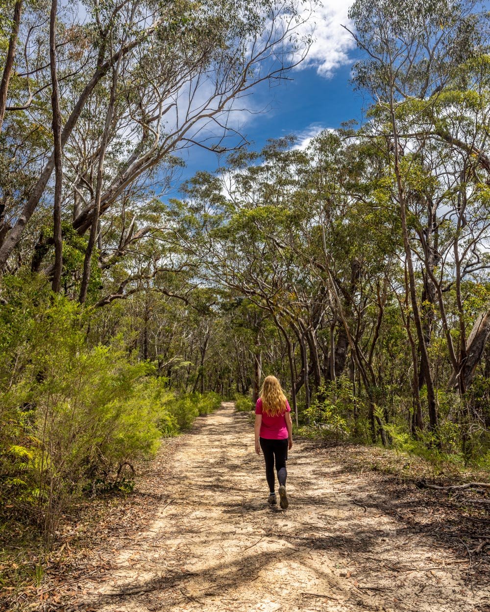
You’ll start on Cliff Drive and head immediately down into the bush on a good path. Although you will be descending from the off, it’s a leisurely bush track for the first 250m.

After this you will begin to descend into the gully. Whilst there is a path the whole way down the Devils Hole, it is sometimes easy to lose it.
However, the rocky terrain is not too difficult to descend anyway, especially for the first half of the track.
In all honesty, you probably only need to go down to the giant overhang to the right of the boulder if you’re not doing the circuit walk, because this is where the real wow factor views are and also the easiest part of the track. If you do this you are only descending 150m of the gully itself.
There is a further 250m of the gully to go if you want to complete the whole track, but you will have seen the best of the scenery already in my opinion - so it depends how you’re finding it.


The caveat to this is I do think continuing another 100m or so will give you that classic distant chockstone (boulder wedge) view from below, so if it feels nice and easy, then it’s well worth heading on a bit further, but if not, then know you have still experienced the best of the scenery.
If you continue beyond the overhang you will encounter a few bits where you have to climb down some rocks rather than walk over them, but it’s easy enough when dry.

When you’ve finished exploring, retrace your steps back up to Cliff Drive again. The climb is steep until you meet the bush track again, but it’s such amazing views that you will likely stop many times so you can break it up nicely.
And the views do look different on the way up to the way down, so you can definitely take your time in both directions.
What to expect from the Devils Hole itself
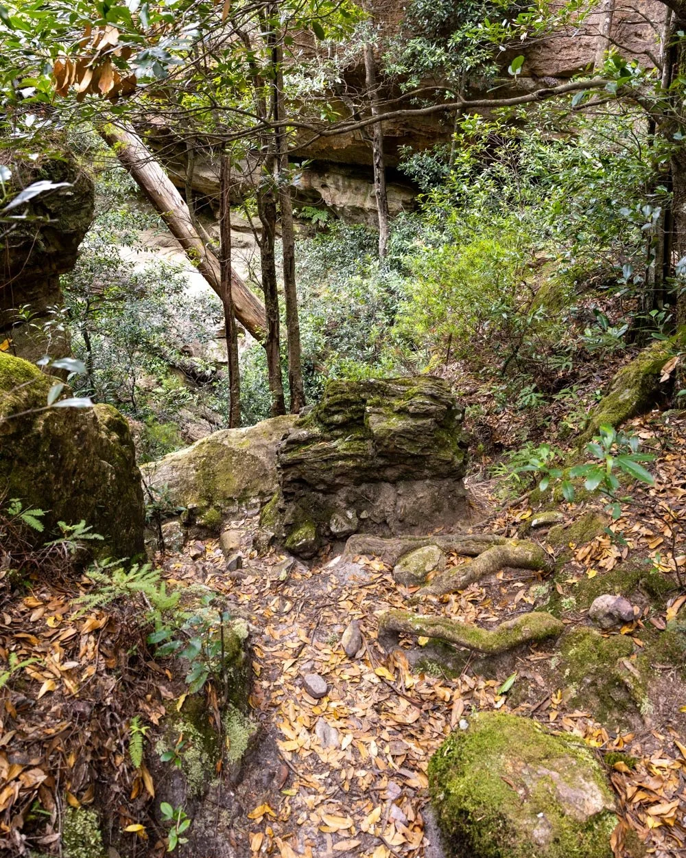
The Devils Hole is basically a rocky gully between two giant cliff walls that have a large boulder wedged between them - it really is a very cool view from both angles, above and below.
Though there is a path, it’s discreet and therefore the whole scene feels really wild. The landscape is strewn with giant boulders and jagged rocks and there are ferns growing from every gap inbetween.
There’s a large overhang (which is slanted and has some loose rock, so take care) which offers a great view of the mountains beyond.

It’s hard to really describe why this is such a special spot, it’s the untouched scenery, but also the atmosphere. It has a remote, almost prehistoric vibe which is crazy to think when it’s only a few hundred metres below Cliff Drive!
I think it’s one of those places you just have to experience for yourself.

The Devils Hole and Nellies Glen Circuit
The stats
Distance: 10.5km circuit
Elevation gain: 510m
Difficulty: Moderate when dry, hard when wet
Starting the trail: to the lookouts
From the parking area (which is more of a layby) on Stuarts Road, the walk heads down the road and then left for 30m before you see a right hand turn into the bush (after a further 30m).
Although this is a circuit track and could therefore be walked in either direction, we think it’s easier to ascend the Devils Hole, which is why we started on Stuarts Road rather than at the trailhead for the Devils Hole on Cliff Drive.

The first 250m of the track are flat before you start to descend. It’s on a good path, although despite the fact you’re in the bush, it’s a little sparse and therefore doesn’t actually offer much shade.
After another 100m gentle descending you’ll pass over a small wooden bridge, it’s missing a few planks, but still felt sturdy enough.

The track will now begin to undulate, but it’s never steep. Roughly 650 - 700m into the walk you should pass a turnoff for Therabulat Lookout. Unfortunately we clearly weren’t keeping a keen eye out because we walked right past it.
Luckily there’s a second lookout which was very pretty and this one was easy to spot. You’ll see the turn off for Norths Lookout 1.45km into the walk and you’ll reach it 50m later.

Descending on the Six Foot Track
From the junction with Norths Lookout you head gently uphill and will come to a large gate at the 1.7km mark. You pass around the gate and head left onto the Six Foot Track.
This is where you begin your long descent to Nellies Glen. The good news is that all but a few steps are on a really well maintained path, which makes the descent very easy. Just 150m beyond the gate you’ll pass through a small pedestrian only gate and from here it gets greener and more shady.

Your descent is on a series of steps and the forest gets more damp and cool as you descend. The first 650m are all on excellent stairs before you have a short rocky patch, which is easy enough, but requires watching your footing a little more. You’ll then have a few more steps before it levels out and you will see and hear Bonnie Doon waterfall in the distance.
At the 2.7km mark (on a section of flat track) you need to look for the path heading uphill on the left (there are actually two paths and both will get you there and are similar terrain-wise).


The paths are a bit rocky and uneven, but in just 100m you’ll be standing at the base of Boonie Doon Waterfall. There are a couple of boulders to climb over, but it’s grippy when dry.
Bonnie Doon Waterfall
Boonie Doon Falls is pretty big and would thunder over the cliff in times of high rainfall. At other times she is less powerful and I can imagine may become a mere trickle in very dry times.
For us the flow was quite low and the wind blew the spray which made it appear even less of a waterfall - although the cool mist was a delight on a hot day. Despite the low flow, it was still a lovely spot and there are plenty of giant boulders to relax on.
Although we would have ideally visited after lots of rain, as mentioned, this would make the Devils Hole Track more difficult and we preferred to sacrifice the best view of the falls, rather than risk a slip later on in the walk.

Continuing to Nellies Glen
Back on the main trail and you’ll cross a small creek with rocks to use as stepping stones, before continuing a much more gradual descent. After 400m the path will flatten which begins a very leisurely relaxing part of the trail.
There are two 30m long landslide areas to cross, but they have been completely cleared, so though you must walk quickly incase of additional rockfall, it is a normal path.

After you leave Boonie Doon, it’s all beautifully shaded in the forest. You get occasional glimpses out to the mountains beyond, but for the most part it’s a pretty bushwalk (you’ll pass through Nellies Glen and though there is a sign, it’s not a small rainforest glen in the way I was expecting).
At the 3.7km mark the path will begin descending again before flattening 250m later. When you’ve been walking for 4.1km you will come into a clearing and see a road sign for walkers, which is funny, because you just can’t imagine anyone driving down here!

Leaving the Six Foot Track
The next 2km are all along a fire trail, but honestly it’s really pretty and not a hardship in the least - especially because it’s entirely flat! I am not generally a fan of fire trail walking, but this one was quiet and rather lovely, with dense bush and the odd mountain view.
It was also nice to have such a long time on the flat so you could properly relax between descending and ascending.
Just after the 6.1km mark you’ll leave the Six Foot Track, taking the left turn which is marked with a ‘ladders have been removed’ sign.


These ladders are not relevant to the Devils Hole Track, so you don’t need to worry. It actually refers to the old water board ladders, the remains of which you can divert to see, though we were hiking on a really hot day and decided not to detour.
Once you’ve made the turning off the Six Foot Track you have 350m of easy flat walking left before you begin to ascend. The first 500m of the ascent are gentle and on this same easy path.

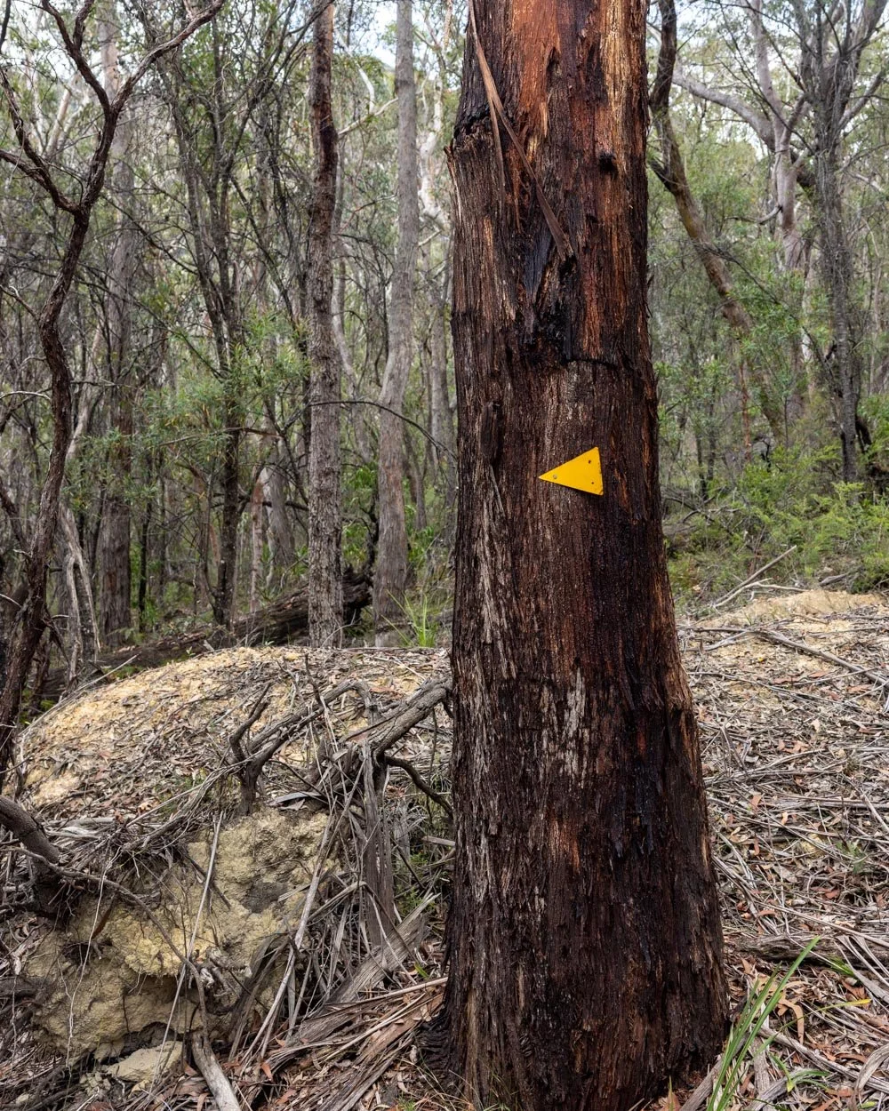
At the 7km mark (or 850m beyond the turn off) you need to look for the path heading into the bush on the left. It’s marked by a big cairn and a yellow triangle on the tree, so it’s quite hard to miss unless you’re really engrossed in conversation!
From here the track will be more narrow and overgrown, but still very easy to follow for quite some time.
The path gets rougher
After 150m you will make a tiny creek crossing (easy) and then begin following the red tags. They were quite easy to spot even though the track does get a bit more overgrown.
Roughly 300m after the initial turn off into the bush the path begins to head more steeply uphill, but it is also a very obvious track, so there are no more tags required.


After another 300m it gets steeper and rougher again, but is not slippery (when dry). After another 200m you’ll enter what feels more like a rainforest environment and the path is now covered in leaf litter.
When ascending, it’s not too slippery, but I would not want to descend this section! Roughly 500m later (8.3km into the track) you have a short period where the trail is indistinct.

The path is looser, rougher and steeper for the next 100m. This is normally my worst kind of terrain, but as it was dry it wasn’t slippery and there were plenty of rocks to hold onto when necessary. However, as with the leaf litter section I would not want to descend this bit.

The trail weaves right, then left, then right and is marked by cairns at each turn - if you don’t see the cairn at first keep looking because they were at every point you needed them. Additionally there are yellow and blue tags, so there’s plenty of indicators to give a helping hand if needed.


There are usually a couple of ways you can go, but spotting the cairns will be reassuring if you don’t enjoy finding your own path.
After this there is a short section of normal bush track, past an overhang and round a corner to where you will see a signpost for the Devils Hole Track (just under 8.5km into the walk).

Ascending the Devils Hole Track
I’ve basically already described this in the short track section above, but in essence the next 400m before you hit the bush track are all uphill on a rocky path.
Sometimes, especially in the first 50m, the path is easy to miss and you may stray from it. However, you will be climbing up rocks which is easy enough when dry and though there are a few rubbly bits, it wasn’t slippery.


After 150m you’ll see the chockstone above you and the path has a few bits where you are climbing up rocks rather than walking on a stony track. You’ll no doubt stop often to admire the incredible scenery, so though it’s steep, it actually doesn’t feel too difficult because you’re only walking tiny sections at a time.

You’ll pass a big overhang with amazing views and then get a view of the boulder from a different angle and much closer up. From the overhang you have a further 150m of similar terrain before you hit the bush track.


At that point you are 250m from Cliff Drive. The walk is still predominantly uphill, but at a gentler gradient and on a normal track.
Sadly the last 1.3km back to your car is all along the road. You’ll turn right on Cliff Drive before turning left onto Narrow Neck Road. Roughly 700m later you will turn left onto Stuart’s Road and from here you are 400m from the layby.
The road goes gradually uphill at first and then downhill. It’s not the most fun end to the walk, but it’s worth it!
Parking for the Devils Hole Track
For the short version of the track you can park fully off the road on a gravel patch beside the signpost for the Devils Hole Track on Cliff Drive in Katoomba (you can see it here on Google maps). If you want to do the full circuit it’s better to park at the layby on Stuarts Road, so that you complete the circuit anticlockwise, which is the easiest route. There is room for several cars at the main trail head and only a couple at the layby, but it isn’t a busy walk, so you shouldn’t have any trouble getting a spot.
There are currently no parking restrictions at either spot and at time of writing parking at this point on Cliff Drive does not fall into the fee zone.
If you don’t have a car the open top bus actually stops right at the Devils Hole Track signpost - no idea why but it’s handy!
This post may contain affiliate links, meaning at no additional cost to you, that we will earn a small commission if you click through and decide to make a purchase. This helps towards the costs of running our website. Thanks for your support.


